You are here: Home > Network List > WY - Yellowstone Wyoming Seismic Network Stations List
> Station YHH Holmes Hill, YNP, WY, USA > Earthquake Result Viewer
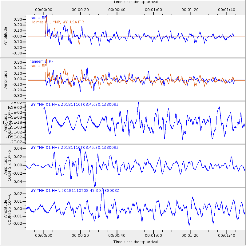
YHH Holmes Hill, YNP, WY, USA - Earthquake Result Viewer
*The percent match for this event was below the threshold and hence no stack was calculated.
| Earthquake location: |
Tonga Islands |
| Earthquake latitude/longitude: |
-20.5/-173.8 |
| Earthquake time(UTC): |
2018/11/10 (314) 08:33:16 GMT |
| Earthquake Depth: |
10 km |
| Earthquake Magnitude: |
6.2 Mww |
| Earthquake Catalog/Contributor: |
NEIC PDE/us |
|
| Network: |
WY Yellowstone Wyoming Seismic Network |
| Station: |
YHH Holmes Hill, YNP, WY, USA |
| Lat/Lon: |
44.79 N/110.85 W |
| Elevation: |
2717 m |
|
| Distance: |
86.6 deg |
| Az: |
39.448 deg |
| Baz: |
236.749 deg |
| Ray Param: |
$rayparam |
*The percent match for this event was below the threshold and hence was not used in the summary stack. |
|
| Radial Match: |
65.359436 % |
| Radial Bump: |
400 |
| Transverse Match: |
77.44121 % |
| Transverse Bump: |
400 |
| SOD ConfigId: |
13570011 |
| Insert Time: |
2019-05-01 19:12:57.435 +0000 |
| GWidth: |
2.5 |
| Max Bumps: |
400 |
| Tol: |
0.001 |
|
Signal To Noise
| Channel | StoN | STA | LTA |
| WY:YHH:01:HHZ:20181110T08:45:30.138008Z | 1.0177441 | 2.5335554E-9 | 2.4893836E-9 |
| WY:YHH:01:HHN:20181110T08:45:30.138008Z | 0.96400094 | 3.071474E-9 | 3.1861733E-9 |
| WY:YHH:01:HHE:20181110T08:45:30.138008Z | 0.56863624 | 3.2499454E-9 | 5.715333E-9 |
| Arrivals |
| Ps | |
| PpPs | |
| PsPs/PpSs | |


