You are here: Home > Network List > TS - TERRAscope (Southern California Seismic Network) Stations List
> Station BAR Barrett Dam, California, USA > Earthquake Result Viewer
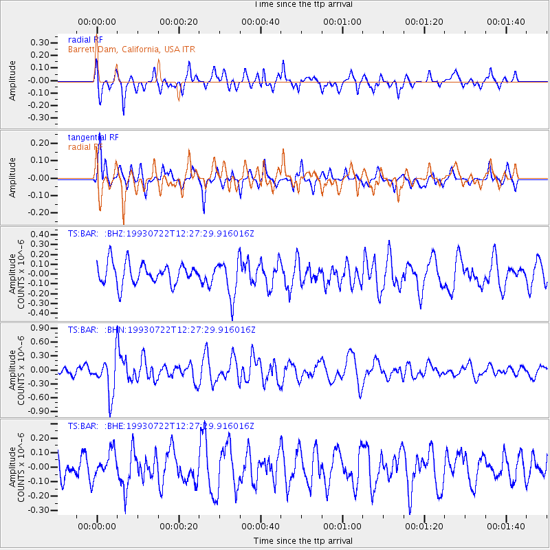
BAR Barrett Dam, California, USA - Earthquake Result Viewer
*The percent match for this event was below the threshold and hence no stack was calculated.
| Earthquake location: |
Mariana Islands Region |
| Earthquake latitude/longitude: |
21.8/144.2 |
| Earthquake time(UTC): |
1993/07/22 (203) 12:15:36 GMT |
| Earthquake Depth: |
126 km |
| Earthquake Magnitude: |
5.5 MB, 5.8 UNKNOWN |
| Earthquake Catalog/Contributor: |
WHDF/NEIC |
|
| Network: |
TS TERRAscope (Southern California Seismic Network) |
| Station: |
BAR Barrett Dam, California, USA |
| Lat/Lon: |
32.68 N/116.67 W |
| Elevation: |
548 m |
|
| Distance: |
85.8 deg |
| Az: |
56.612 deg |
| Baz: |
293.029 deg |
| Ray Param: |
$rayparam |
*The percent match for this event was below the threshold and hence was not used in the summary stack. |
|
| Radial Match: |
61.628155 % |
| Radial Bump: |
400 |
| Transverse Match: |
63.434002 % |
| Transverse Bump: |
336 |
| SOD ConfigId: |
4480 |
| Insert Time: |
2010-02-26 14:00:26.850 +0000 |
| GWidth: |
2.5 |
| Max Bumps: |
400 |
| Tol: |
0.001 |
|
Signal To Noise
| Channel | StoN | STA | LTA |
| TS:BAR: :BHN:19930722T12:27:29.916016Z | 4.643967 | 4.2289824E-7 | 9.1064E-8 |
| TS:BAR: :BHE:19930722T12:27:29.916016Z | 0.74683964 | 8.767662E-8 | 1.17396844E-7 |
| TS:BAR: :BHZ:19930722T12:27:29.916016Z | 1.822666 | 1.9454663E-7 | 1.067374E-7 |
| Arrivals |
| Ps | |
| PpPs | |
| PsPs/PpSs | |


