You are here: Home > Network List > TA - USArray Transportable Network (new EarthScope stations) Stations List
> Station Z14A Wintersburg, AZ, USA > Earthquake Result Viewer
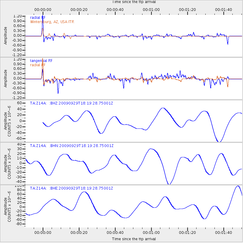
Z14A Wintersburg, AZ, USA - Earthquake Result Viewer
*The percent match for this event was below the threshold and hence no stack was calculated.
| Earthquake location: |
Samoa Islands Region |
| Earthquake latitude/longitude: |
-15.6/-172.0 |
| Earthquake time(UTC): |
2009/09/29 (272) 18:08:21 GMT |
| Earthquake Depth: |
10 km |
| Earthquake Magnitude: |
5.6 MB |
| Earthquake Catalog/Contributor: |
WHDF/NEIC |
|
| Network: |
TA USArray Transportable Network (new EarthScope stations) |
| Station: |
Z14A Wintersburg, AZ, USA |
| Lat/Lon: |
33.36 N/112.95 W |
| Elevation: |
298 m |
|
| Distance: |
74.4 deg |
| Az: |
48.184 deg |
| Baz: |
239.13 deg |
| Ray Param: |
$rayparam |
*The percent match for this event was below the threshold and hence was not used in the summary stack. |
|
| Radial Match: |
61.74397 % |
| Radial Bump: |
400 |
| Transverse Match: |
63.92594 % |
| Transverse Bump: |
345 |
| SOD ConfigId: |
2622 |
| Insert Time: |
2010-03-06 17:51:08.489 +0000 |
| GWidth: |
2.5 |
| Max Bumps: |
400 |
| Tol: |
0.001 |
|
Signal To Noise
| Channel | StoN | STA | LTA |
| TA:Z14A: :BHN:20090929T18:19:28.75001Z | 2.041409 | 2.1543856E-5 | 1.05534245E-5 |
| TA:Z14A: :BHE:20090929T18:19:28.75001Z | 1.5147265 | 3.3073862E-5 | 2.1834872E-5 |
| TA:Z14A: :BHZ:20090929T18:19:28.75001Z | 2.5461206 | 3.7631085E-5 | 1.4779772E-5 |
| Arrivals |
| Ps | |
| PpPs | |
| PsPs/PpSs | |


