You are here: Home > Network List > AE - Arizona Broadband Seismic Network Stations List
> Station PRCT Prescott > Earthquake Result Viewer
PRCT Prescott - Earthquake Result Viewer
| Earthquake location: |
North Atlantic Ocean |
| Earthquake latitude/longitude: |
15.6/-49.9 |
| Earthquake time(UTC): |
2018/11/11 (315) 14:03:59 GMT |
| Earthquake Depth: |
10 km |
| Earthquake Magnitude: |
6.2 mb |
| Earthquake Catalog/Contributor: |
NEIC PDE/us |
|
| Network: |
AE Arizona Broadband Seismic Network |
| Station: |
PRCT Prescott |
| Lat/Lon: |
35.06 N/112.71 W |
| Elevation: |
1410 m |
|
| Distance: |
59.1 deg |
| Az: |
301.724 deg |
| Baz: |
92.19 deg |
| Ray Param: |
0.062401365 |
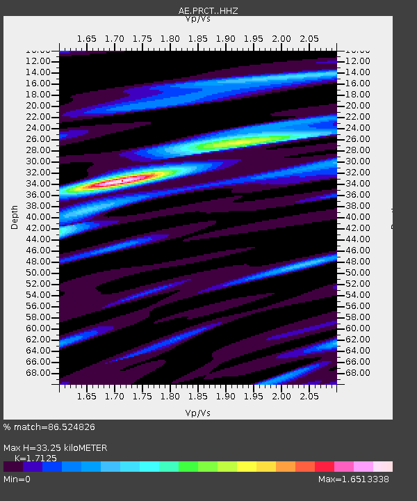
| Estimated Moho Depth: |
33.25 km |
| Estimated Crust Vp/Vs: |
1.71 |
| Assumed Crust Vp: |
6.276 km/s |
| Estimated Crust Vs: |
3.665 km/s |
| Estimated Crust Poisson's Ratio: |
0.24 |
|
| Radial Match: |
86.524826 % |
| Radial Bump: |
400 |
| Transverse Match: |
70.247406 % |
| Transverse Bump: |
400 |
| SOD ConfigId: |
13570011 |
| Insert Time: |
2019-05-01 19:14:31.374 +0000 |
| GWidth: |
2.5 |
| Max Bumps: |
400 |
| Tol: |
0.001 |
|

Signal To Noise
| Channel | StoN | STA | LTA |
| AE:PRCT: :HHZ:20181111T14:13:28.960024Z | 8.437176 | 9.48372E-7 | 1.1240397E-7 |
| AE:PRCT: :HHN:20181111T14:13:28.960024Z | 1.9316243 | 1.6066376E-7 | 8.3175465E-8 |
| AE:PRCT: :HHE:20181111T14:13:28.960024Z | 3.3422947 | 4.4392297E-7 | 1.3281982E-7 |
| Arrivals |
| Ps | 4.0 SECOND |
| PpPs | 14 SECOND |
| PsPs/PpSs | 18 SECOND |


