You are here: Home > Network List > TA - USArray Transportable Network (new EarthScope stations) Stations List
> Station Z14A Wintersburg, AZ, USA > Earthquake Result Viewer
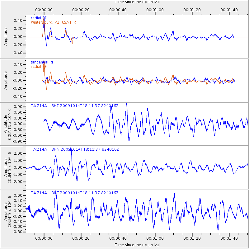
Z14A Wintersburg, AZ, USA - Earthquake Result Viewer
*The percent match for this event was below the threshold and hence no stack was calculated.
| Earthquake location: |
Samoa Islands Region |
| Earthquake latitude/longitude: |
-14.9/-174.8 |
| Earthquake time(UTC): |
2009/10/14 (287) 18:00:21 GMT |
| Earthquake Depth: |
10 km |
| Earthquake Magnitude: |
5.7 MB, 6.0 MS, 6.3 MW, 6.2 MW |
| Earthquake Catalog/Contributor: |
WHDF/NEIC |
|
| Network: |
TA USArray Transportable Network (new EarthScope stations) |
| Station: |
Z14A Wintersburg, AZ, USA |
| Lat/Lon: |
33.36 N/112.95 W |
| Elevation: |
298 m |
|
| Distance: |
76.0 deg |
| Az: |
49.516 deg |
| Baz: |
241.475 deg |
| Ray Param: |
$rayparam |
*The percent match for this event was below the threshold and hence was not used in the summary stack. |
|
| Radial Match: |
76.68133 % |
| Radial Bump: |
374 |
| Transverse Match: |
60.15413 % |
| Transverse Bump: |
368 |
| SOD ConfigId: |
2622 |
| Insert Time: |
2010-03-06 17:51:21.246 +0000 |
| GWidth: |
2.5 |
| Max Bumps: |
400 |
| Tol: |
0.001 |
|
Signal To Noise
| Channel | StoN | STA | LTA |
| TA:Z14A: :BHN:20091014T18:11:37.824016Z | 2.7760944 | 4.6219165E-7 | 1.6648988E-7 |
| TA:Z14A: :BHE:20091014T18:11:37.824016Z | 0.7181072 | 1.7454306E-7 | 2.4305987E-7 |
| TA:Z14A: :BHZ:20091014T18:11:37.824016Z | 2.2811568 | 3.6874135E-7 | 1.6164664E-7 |
| Arrivals |
| Ps | |
| PpPs | |
| PsPs/PpSs | |


