You are here: Home > Network List > AZ - ANZA Regional Network Stations List
> Station SMER AZ.SMER > Earthquake Result Viewer
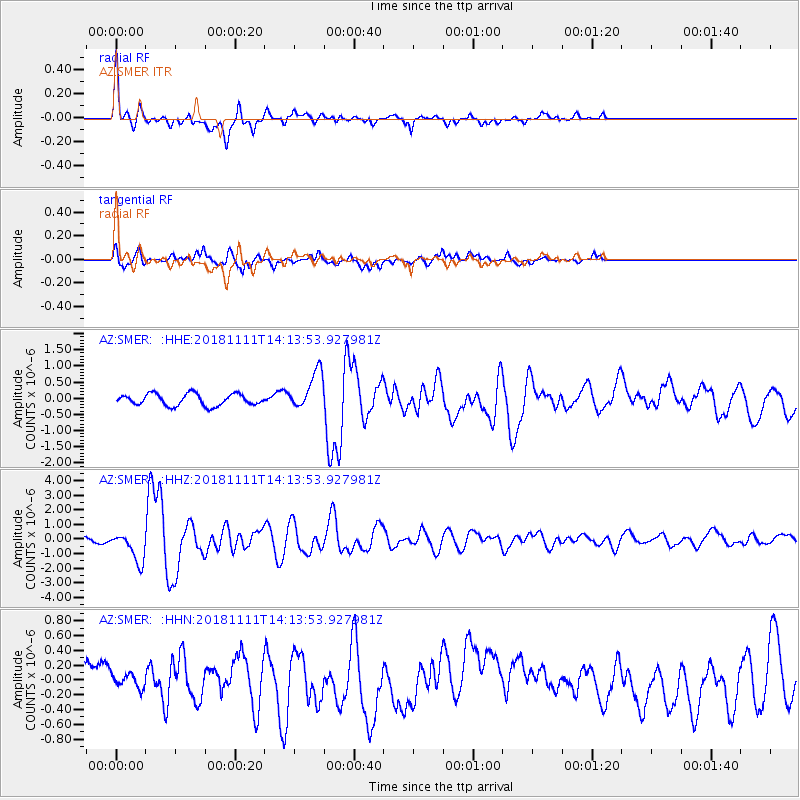
SMER AZ.SMER - Earthquake Result Viewer
*The percent match for this event was below the threshold and hence no stack was calculated.
| Earthquake location: |
North Atlantic Ocean |
| Earthquake latitude/longitude: |
15.6/-49.9 |
| Earthquake time(UTC): |
2018/11/11 (315) 14:03:59 GMT |
| Earthquake Depth: |
10 km |
| Earthquake Magnitude: |
6.2 mb |
| Earthquake Catalog/Contributor: |
NEIC PDE/us |
|
| Network: |
AZ ANZA Regional Network |
| Station: |
SMER AZ.SMER |
| Lat/Lon: |
33.46 N/117.17 W |
| Elevation: |
355 m |
|
| Distance: |
62.8 deg |
| Az: |
299.866 deg |
| Baz: |
88.787 deg |
| Ray Param: |
$rayparam |
*The percent match for this event was below the threshold and hence was not used in the summary stack. |
|
| Radial Match: |
77.53513 % |
| Radial Bump: |
400 |
| Transverse Match: |
60.311016 % |
| Transverse Bump: |
400 |
| SOD ConfigId: |
13570011 |
| Insert Time: |
2019-05-01 19:15:45.806 +0000 |
| GWidth: |
2.5 |
| Max Bumps: |
400 |
| Tol: |
0.001 |
|
Signal To Noise
| Channel | StoN | STA | LTA |
| AZ:SMER: :HHZ:20181111T14:13:53.927981Z | 8.983358 | 1.0453331E-6 | 1.1636328E-7 |
| AZ:SMER: :HHN:20181111T14:13:53.927981Z | 0.5422663 | 1.3270333E-7 | 2.4471984E-7 |
| AZ:SMER: :HHE:20181111T14:13:53.927981Z | 3.2899091 | 5.887093E-7 | 1.7894395E-7 |
| Arrivals |
| Ps | |
| PpPs | |
| PsPs/PpSs | |


