You are here: Home > Network List > C1 - Red Sismologica Nacional Stations List
> Station BO01 Tunca > Earthquake Result Viewer
BO01 Tunca - Earthquake Result Viewer
| Earthquake location: |
North Atlantic Ocean |
| Earthquake latitude/longitude: |
15.6/-49.9 |
| Earthquake time(UTC): |
2018/11/11 (315) 14:03:59 GMT |
| Earthquake Depth: |
10 km |
| Earthquake Magnitude: |
6.2 mb |
| Earthquake Catalog/Contributor: |
NEIC PDE/us |
|
| Network: |
C1 Red Sismologica Nacional |
| Station: |
BO01 Tunca |
| Lat/Lon: |
34.39 S/71.08 W |
| Elevation: |
262 m |
|
| Distance: |
53.6 deg |
| Az: |
201.825 deg |
| Baz: |
25.677 deg |
| Ray Param: |
0.065975405 |
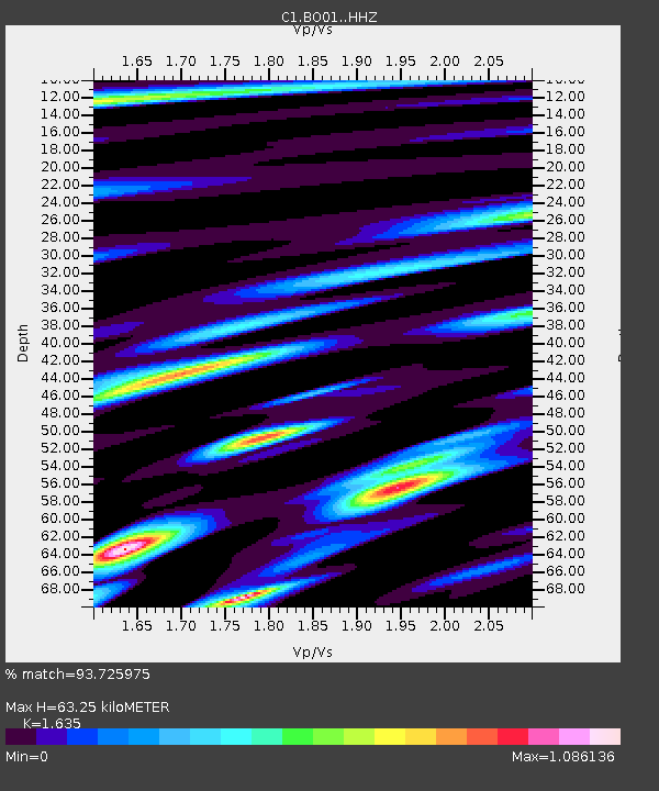
| Estimated Moho Depth: |
63.25 km |
| Estimated Crust Vp/Vs: |
1.63 |
| Assumed Crust Vp: |
6.481 km/s |
| Estimated Crust Vs: |
3.964 km/s |
| Estimated Crust Poisson's Ratio: |
0.20 |
|
| Radial Match: |
93.725975 % |
| Radial Bump: |
400 |
| Transverse Match: |
87.89881 % |
| Transverse Bump: |
400 |
| SOD ConfigId: |
13570011 |
| Insert Time: |
2019-05-01 19:16:22.524 +0000 |
| GWidth: |
2.5 |
| Max Bumps: |
400 |
| Tol: |
0.001 |
|

Signal To Noise
| Channel | StoN | STA | LTA |
| C1:BO01: :HHZ:20181111T14:12:49.940005Z | 19.979425 | 3.214771E-6 | 1.6090407E-7 |
| C1:BO01: :HHN:20181111T14:12:49.940005Z | 9.294174 | 1.5803388E-6 | 1.7003542E-7 |
| C1:BO01: :HHE:20181111T14:12:49.940005Z | 3.7862504 | 6.337032E-7 | 1.673696E-7 |
| Arrivals |
| Ps | 6.6 SECOND |
| PpPs | 24 SECOND |
| PsPs/PpSs | 31 SECOND |


