You are here: Home > Network List > G - GEOSCOPE Stations List
> Station MPG Montagne des Peres, French Guyana > Earthquake Result Viewer
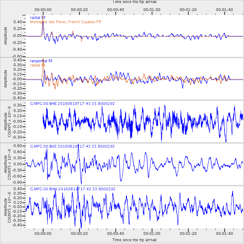
MPG Montagne des Peres, French Guyana - Earthquake Result Viewer
*The percent match for this event was below the threshold and hence no stack was calculated.
| Earthquake location: |
South Georgia Island Region |
| Earthquake latitude/longitude: |
-55.2/-32.1 |
| Earthquake time(UTC): |
2016/08/19 (232) 17:33:40 GMT |
| Earthquake Depth: |
4.3 km |
| Earthquake Magnitude: |
5.8 MWW, 5.7 MWB, 5.8 MWC |
| Earthquake Catalog/Contributor: |
NEIC PDE/NEIC COMCAT |
|
| Network: |
G GEOSCOPE |
| Station: |
MPG Montagne des Peres, French Guyana |
| Lat/Lon: |
5.11 N/52.64 W |
| Elevation: |
147 m |
|
| Distance: |
62.5 deg |
| Az: |
336.757 deg |
| Baz: |
166.875 deg |
| Ray Param: |
$rayparam |
*The percent match for this event was below the threshold and hence was not used in the summary stack. |
|
| Radial Match: |
70.23741 % |
| Radial Bump: |
400 |
| Transverse Match: |
63.829994 % |
| Transverse Bump: |
400 |
| SOD ConfigId: |
1634031 |
| Insert Time: |
2016-09-02 17:34:34.433 +0000 |
| GWidth: |
2.5 |
| Max Bumps: |
400 |
| Tol: |
0.001 |
|
Signal To Noise
| Channel | StoN | STA | LTA |
| G:MPG:00:BHZ:20160819T17:43:33.800029Z | 3.0038707 | 3.916603E-7 | 1.303852E-7 |
| G:MPG:00:BHN:20160819T17:43:33.800029Z | 1.7505528 | 1.4632883E-7 | 8.3590066E-8 |
| G:MPG:00:BHE:20160819T17:43:33.800029Z | 1.3561755 | 1.1928446E-7 | 8.795651E-8 |
| Arrivals |
| Ps | |
| PpPs | |
| PsPs/PpSs | |


