You are here: Home > Network List > C1 - Red Sismologica Nacional Stations List
> Station CO10 PUNTA DE CHOROS > Earthquake Result Viewer
CO10 PUNTA DE CHOROS - Earthquake Result Viewer
| Earthquake location: |
North Atlantic Ocean |
| Earthquake latitude/longitude: |
15.6/-49.9 |
| Earthquake time(UTC): |
2018/11/11 (315) 14:03:59 GMT |
| Earthquake Depth: |
10 km |
| Earthquake Magnitude: |
6.2 mb |
| Earthquake Catalog/Contributor: |
NEIC PDE/us |
|
| Network: |
C1 Red Sismologica Nacional |
| Station: |
CO10 PUNTA DE CHOROS |
| Lat/Lon: |
29.24 S/71.46 W |
| Elevation: |
35 m |
|
| Distance: |
49.2 deg |
| Az: |
205.154 deg |
| Baz: |
27.953 deg |
| Ray Param: |
0.06886368 |
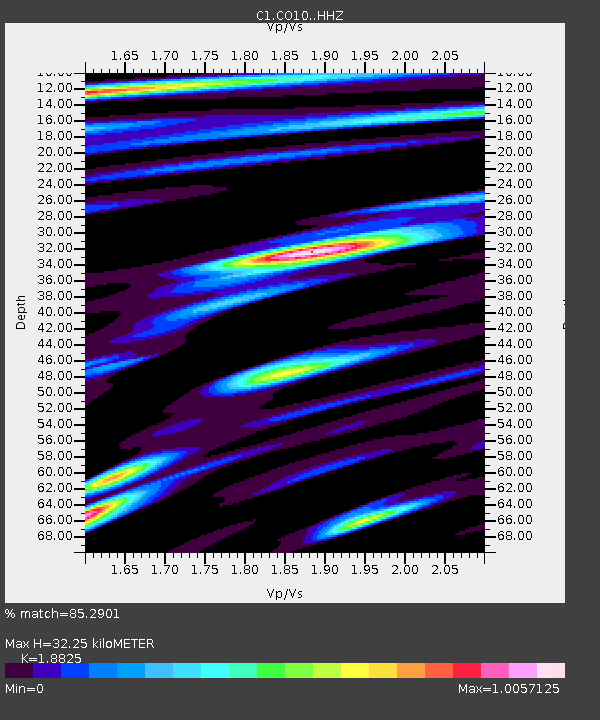
| Estimated Moho Depth: |
32.25 km |
| Estimated Crust Vp/Vs: |
1.88 |
| Assumed Crust Vp: |
6.481 km/s |
| Estimated Crust Vs: |
3.443 km/s |
| Estimated Crust Poisson's Ratio: |
0.30 |
|
| Radial Match: |
85.2901 % |
| Radial Bump: |
400 |
| Transverse Match: |
66.98802 % |
| Transverse Bump: |
400 |
| SOD ConfigId: |
13570011 |
| Insert Time: |
2019-05-01 19:16:27.209 +0000 |
| GWidth: |
2.5 |
| Max Bumps: |
400 |
| Tol: |
0.001 |
|

Signal To Noise
| Channel | StoN | STA | LTA |
| C1:CO10: :HHZ:20181111T14:12:16.729006Z | 10.407996 | 3.5203748E-6 | 3.3823753E-7 |
| C1:CO10: :HHN:20181111T14:12:16.729006Z | 4.5027795 | 1.2903565E-6 | 2.8656888E-7 |
| C1:CO10: :HHE:20181111T14:12:16.729006Z | 3.2021136 | 7.7812814E-7 | 2.4300454E-7 |
| Arrivals |
| Ps | 4.6 SECOND |
| PpPs | 14 SECOND |
| PsPs/PpSs | 18 SECOND |


