You are here: Home > Network List > CC - Cascade Chain Volcano Monitoring Stations List
> Station SWNB Southwest, Newberry, OR > Earthquake Result Viewer
SWNB Southwest, Newberry, OR - Earthquake Result Viewer
| Earthquake location: |
North Atlantic Ocean |
| Earthquake latitude/longitude: |
15.6/-49.9 |
| Earthquake time(UTC): |
2018/11/11 (315) 14:03:59 GMT |
| Earthquake Depth: |
10 km |
| Earthquake Magnitude: |
6.2 mb |
| Earthquake Catalog/Contributor: |
NEIC PDE/us |
|
| Network: |
CC Cascade Chain Volcano Monitoring |
| Station: |
SWNB Southwest, Newberry, OR |
| Lat/Lon: |
43.67 N/121.36 W |
| Elevation: |
1569 m |
|
| Distance: |
66.1 deg |
| Az: |
311.173 deg |
| Baz: |
91.071 deg |
| Ray Param: |
0.057850234 |
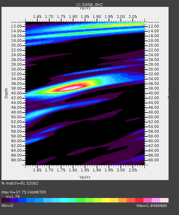
| Estimated Moho Depth: |
37.75 km |
| Estimated Crust Vp/Vs: |
1.79 |
| Assumed Crust Vp: |
6.597 km/s |
| Estimated Crust Vs: |
3.686 km/s |
| Estimated Crust Poisson's Ratio: |
0.27 |
|
| Radial Match: |
91.52062 % |
| Radial Bump: |
400 |
| Transverse Match: |
76.04643 % |
| Transverse Bump: |
400 |
| SOD ConfigId: |
13570011 |
| Insert Time: |
2019-05-01 19:17:14.003 +0000 |
| GWidth: |
2.5 |
| Max Bumps: |
400 |
| Tol: |
0.001 |
|

Signal To Noise
| Channel | StoN | STA | LTA |
| CC:SWNB: :BHZ:20181111T14:14:15.380007Z | 7.348 | 1.0831083E-6 | 1.4740178E-7 |
| CC:SWNB: :BHN:20181111T14:14:15.380007Z | 0.7833378 | 1.4259705E-7 | 1.8203775E-7 |
| CC:SWNB: :BHE:20181111T14:14:15.380007Z | 2.6680245 | 4.821094E-7 | 1.8069899E-7 |
| Arrivals |
| Ps | 4.7 SECOND |
| PpPs | 15 SECOND |
| PsPs/PpSs | 20 SECOND |


