You are here: Home > Network List > GT - Global Telemetered Seismograph Network (USAF/USGS) Stations List
> Station LPAZ La Paz , Bolivia > Earthquake Result Viewer
LPAZ La Paz , Bolivia - Earthquake Result Viewer
| Earthquake location: |
South Georgia Island Region |
| Earthquake latitude/longitude: |
-55.2/-32.1 |
| Earthquake time(UTC): |
2016/08/19 (232) 17:33:40 GMT |
| Earthquake Depth: |
4.3 km |
| Earthquake Magnitude: |
5.8 MWW, 5.7 MWB, 5.8 MWC |
| Earthquake Catalog/Contributor: |
NEIC PDE/NEIC COMCAT |
|
| Network: |
GT Global Telemetered Seismograph Network (USAF/USGS) |
| Station: |
LPAZ La Paz , Bolivia |
| Lat/Lon: |
16.17 S/68.08 W |
| Elevation: |
4817 m |
|
| Distance: |
47.7 deg |
| Az: |
310.257 deg |
| Baz: |
152.922 deg |
| Ray Param: |
0.06980674 |
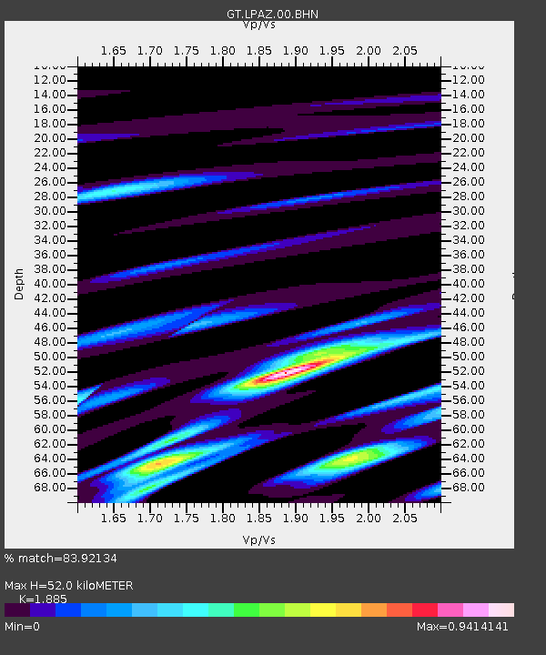
| Estimated Moho Depth: |
52.0 km |
| Estimated Crust Vp/Vs: |
1.88 |
| Assumed Crust Vp: |
6.454 km/s |
| Estimated Crust Vs: |
3.424 km/s |
| Estimated Crust Poisson's Ratio: |
0.30 |
|
| Radial Match: |
83.92134 % |
| Radial Bump: |
400 |
| Transverse Match: |
77.2596 % |
| Transverse Bump: |
400 |
| SOD ConfigId: |
1634031 |
| Insert Time: |
2016-09-02 17:34:56.166 +0000 |
| GWidth: |
2.5 |
| Max Bumps: |
400 |
| Tol: |
0.001 |
|

Signal To Noise
| Channel | StoN | STA | LTA |
| GT:LPAZ:00:BHZ:20160819T17:41:46.924999Z | 6.630672 | 1.0708061E-6 | 1.6149284E-7 |
| GT:LPAZ:00:BHN:20160819T17:41:46.924999Z | 1.9932454 | 2.9039768E-7 | 1.4569088E-7 |
| GT:LPAZ:00:BHE:20160819T17:41:46.924999Z | 3.9678457 | 4.5890474E-7 | 1.1565589E-7 |
| Arrivals |
| Ps | 7.6 SECOND |
| PpPs | 22 SECOND |
| PsPs/PpSs | 29 SECOND |


