You are here: Home > Network List > CI - Caltech Regional Seismic Network Stations List
> Station SHO Shoshone, CA, USA > Earthquake Result Viewer
SHO Shoshone, CA, USA - Earthquake Result Viewer
| Earthquake location: |
North Atlantic Ocean |
| Earthquake latitude/longitude: |
15.6/-49.9 |
| Earthquake time(UTC): |
2018/11/11 (315) 14:03:59 GMT |
| Earthquake Depth: |
10 km |
| Earthquake Magnitude: |
6.2 mb |
| Earthquake Catalog/Contributor: |
NEIC PDE/us |
|
| Network: |
CI Caltech Regional Seismic Network |
| Station: |
SHO Shoshone, CA, USA |
| Lat/Lon: |
35.90 N/116.28 W |
| Elevation: |
451 m |
|
| Distance: |
62.0 deg |
| Az: |
302.61 deg |
| Baz: |
90.564 deg |
| Ray Param: |
0.06048633 |
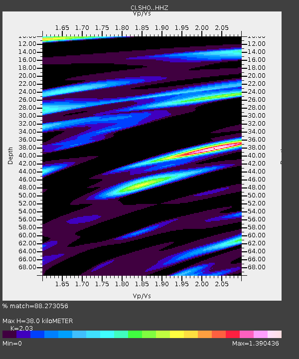
| Estimated Moho Depth: |
38.0 km |
| Estimated Crust Vp/Vs: |
2.03 |
| Assumed Crust Vp: |
6.276 km/s |
| Estimated Crust Vs: |
3.092 km/s |
| Estimated Crust Poisson's Ratio: |
0.34 |
|
| Radial Match: |
88.273056 % |
| Radial Bump: |
400 |
| Transverse Match: |
68.77835 % |
| Transverse Bump: |
400 |
| SOD ConfigId: |
13570011 |
| Insert Time: |
2019-05-01 19:18:02.015 +0000 |
| GWidth: |
2.5 |
| Max Bumps: |
400 |
| Tol: |
0.001 |
|
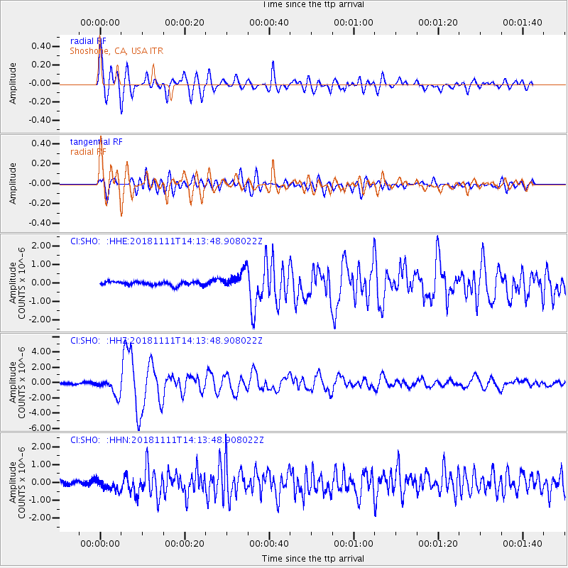
Signal To Noise
| Channel | StoN | STA | LTA |
| CI:SHO: :HHZ:20181111T14:13:48.908022Z | 9.629886 | 1.1310253E-6 | 1.1744952E-7 |
| CI:SHO: :HHN:20181111T14:13:48.908022Z | 2.474485 | 3.7439804E-7 | 1.5130342E-7 |
| CI:SHO: :HHE:20181111T14:13:48.908022Z | 5.327233 | 5.335862E-7 | 1.00161984E-7 |
| Arrivals |
| Ps | 6.5 SECOND |
| PpPs | 18 SECOND |
| PsPs/PpSs | 24 SECOND |


