You are here: Home > Network List > TA - USArray Transportable Network (new EarthScope stations) Stations List
> Station Z14A Wintersburg, AZ, USA > Earthquake Result Viewer
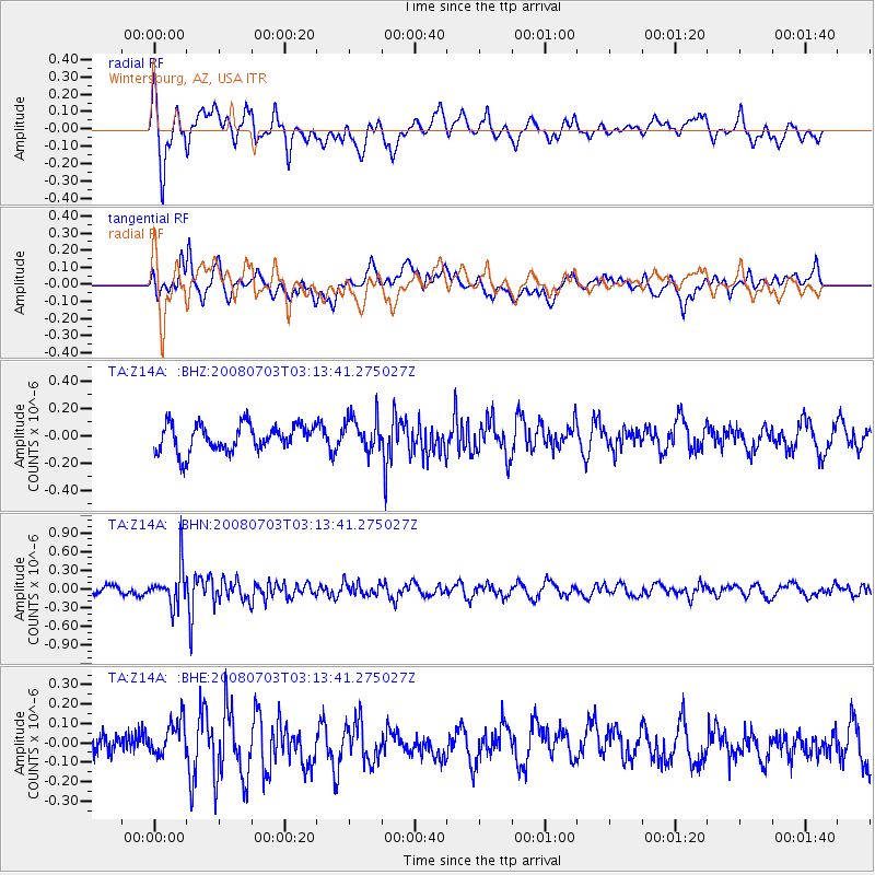
Z14A Wintersburg, AZ, USA - Earthquake Result Viewer
*The percent match for this event was below the threshold and hence no stack was calculated.
| Earthquake location: |
South Of Fiji Islands |
| Earthquake latitude/longitude: |
-23.4/-179.8 |
| Earthquake time(UTC): |
2008/07/03 (185) 03:02:37 GMT |
| Earthquake Depth: |
581 km |
| Earthquake Magnitude: |
5.6 MB, 6.2 MW, 6.2 MW |
| Earthquake Catalog/Contributor: |
WHDF/NEIC |
|
| Network: |
TA USArray Transportable Network (new EarthScope stations) |
| Station: |
Z14A Wintersburg, AZ, USA |
| Lat/Lon: |
33.36 N/112.95 W |
| Elevation: |
298 m |
|
| Distance: |
85.0 deg |
| Az: |
50.562 deg |
| Baz: |
237.996 deg |
| Ray Param: |
$rayparam |
*The percent match for this event was below the threshold and hence was not used in the summary stack. |
|
| Radial Match: |
52.049557 % |
| Radial Bump: |
400 |
| Transverse Match: |
38.91857 % |
| Transverse Bump: |
400 |
| SOD ConfigId: |
2504 |
| Insert Time: |
2010-03-06 17:52:13.616 +0000 |
| GWidth: |
2.5 |
| Max Bumps: |
400 |
| Tol: |
0.001 |
|
Signal To Noise
| Channel | StoN | STA | LTA |
| TA:Z14A: :BHN:20080703T03:13:41.275027Z | 4.632456 | 3.1255814E-7 | 6.7471376E-8 |
| TA:Z14A: :BHE:20080703T03:13:41.275027Z | 0.8066054 | 9.350198E-8 | 1.1592036E-7 |
| TA:Z14A: :BHZ:20080703T03:13:41.275027Z | 1.2601733 | 1.2345947E-7 | 9.797023E-8 |
| Arrivals |
| Ps | |
| PpPs | |
| PsPs/PpSs | |


