You are here: Home > Network List > TA - USArray Transportable Network (new EarthScope stations) Stations List
> Station Z14A Wintersburg, AZ, USA > Earthquake Result Viewer
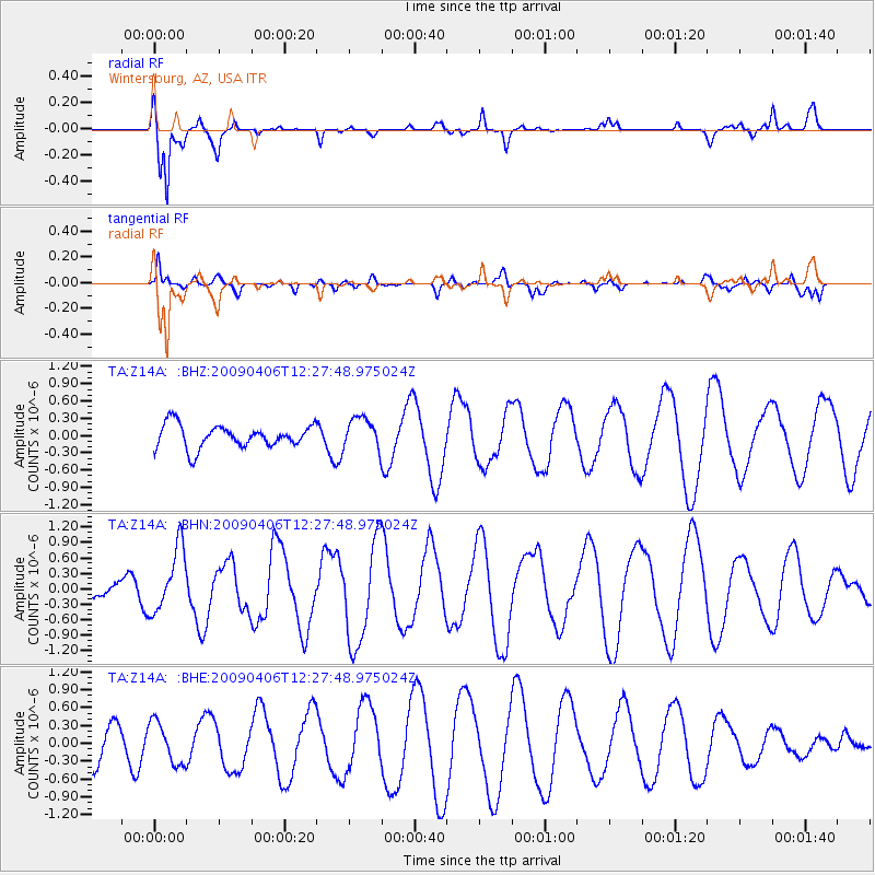
Z14A Wintersburg, AZ, USA - Earthquake Result Viewer
*The percent match for this event was below the threshold and hence no stack was calculated.
| Earthquake location: |
Tonga Islands Region |
| Earthquake latitude/longitude: |
-22.4/-174.9 |
| Earthquake time(UTC): |
2009/04/06 (096) 12:16:08 GMT |
| Earthquake Depth: |
35 km |
| Earthquake Magnitude: |
5.5 MS, 5.4 MB |
| Earthquake Catalog/Contributor: |
WHDF/NEIC |
|
| Network: |
TA USArray Transportable Network (new EarthScope stations) |
| Station: |
Z14A Wintersburg, AZ, USA |
| Lat/Lon: |
33.36 N/112.95 W |
| Elevation: |
298 m |
|
| Distance: |
81.0 deg |
| Az: |
48.426 deg |
| Baz: |
235.827 deg |
| Ray Param: |
$rayparam |
*The percent match for this event was below the threshold and hence was not used in the summary stack. |
|
| Radial Match: |
83.51088 % |
| Radial Bump: |
277 |
| Transverse Match: |
66.19405 % |
| Transverse Bump: |
383 |
| SOD ConfigId: |
2760 |
| Insert Time: |
2010-03-06 17:52:20.697 +0000 |
| GWidth: |
2.5 |
| Max Bumps: |
400 |
| Tol: |
0.001 |
|
Signal To Noise
| Channel | StoN | STA | LTA |
| TA:Z14A: :BHN:20090406T12:27:48.975024Z | 2.793037 | 6.229242E-7 | 2.2302754E-7 |
| TA:Z14A: :BHE:20090406T12:27:48.975024Z | 0.8112097 | 3.5055584E-7 | 4.3213961E-7 |
| TA:Z14A: :BHZ:20090406T12:27:48.975024Z | 1.393025 | 2.779335E-7 | 1.9951796E-7 |
| Arrivals |
| Ps | |
| PpPs | |
| PsPs/PpSs | |


