You are here: Home > Network List > TA - USArray Transportable Network (new EarthScope stations) Stations List
> Station Z14A Wintersburg, AZ, USA > Earthquake Result Viewer
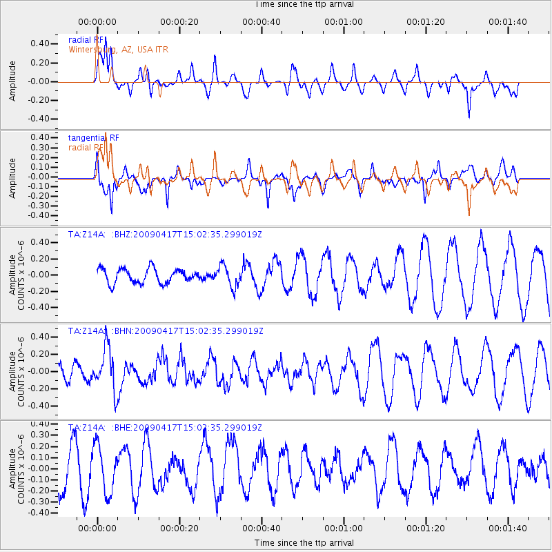
Z14A Wintersburg, AZ, USA - Earthquake Result Viewer
*The percent match for this event was below the threshold and hence no stack was calculated.
| Earthquake location: |
Kuril Islands |
| Earthquake latitude/longitude: |
46.2/151.7 |
| Earthquake time(UTC): |
2009/04/17 (107) 14:51:58 GMT |
| Earthquake Depth: |
49 km |
| Earthquake Magnitude: |
5.5 MB, 5.0 MS, 5.7 MW, 5.6 MW |
| Earthquake Catalog/Contributor: |
WHDF/NEIC |
|
| Network: |
TA USArray Transportable Network (new EarthScope stations) |
| Station: |
Z14A Wintersburg, AZ, USA |
| Lat/Lon: |
33.36 N/112.95 W |
| Elevation: |
298 m |
|
| Distance: |
70.2 deg |
| Az: |
62.352 deg |
| Baz: |
312.643 deg |
| Ray Param: |
$rayparam |
*The percent match for this event was below the threshold and hence was not used in the summary stack. |
|
| Radial Match: |
52.21317 % |
| Radial Bump: |
398 |
| Transverse Match: |
50.571495 % |
| Transverse Bump: |
337 |
| SOD ConfigId: |
2760 |
| Insert Time: |
2010-03-06 17:52:25.240 +0000 |
| GWidth: |
2.5 |
| Max Bumps: |
400 |
| Tol: |
0.001 |
|
Signal To Noise
| Channel | StoN | STA | LTA |
| TA:Z14A: :BHN:20090417T15:02:35.299019Z | 2.530547 | 2.5514592E-7 | 1.0082639E-7 |
| TA:Z14A: :BHE:20090417T15:02:35.299019Z | 1.306247 | 2.1209449E-7 | 1.6236936E-7 |
| TA:Z14A: :BHZ:20090417T15:02:35.299019Z | 1.559725 | 1.3730936E-7 | 8.8034334E-8 |
| Arrivals |
| Ps | |
| PpPs | |
| PsPs/PpSs | |


