You are here: Home > Network List > LD - Lamont-Doherty Cooperative Seismographic Network Stations List
> Station FMMC Franklin & Marshall College/Millport Conservancy, PA > Earthquake Result Viewer
FMMC Franklin & Marshall College/Millport Conservancy, PA - Earthquake Result Viewer

| Earthquake location: |
North Atlantic Ocean |
| Earthquake latitude/longitude: |
15.6/-49.9 |
| Earthquake time(UTC): |
2018/11/11 (315) 14:03:59 GMT |
| Earthquake Depth: |
10 km |
| Earthquake Magnitude: |
6.2 mb |
| Earthquake Catalog/Contributor: |
NEIC PDE/us |
|
| Network: |
LD Lamont-Doherty Cooperative Seismographic Network |
| Station: |
FMMC Franklin & Marshall College/Millport Conservancy, PA |
| Lat/Lon: |
40.14 N/76.26 W |
| Elevation: |
101 m |
|
| Distance: |
33.6 deg |
| Az: |
321.972 deg |
| Baz: |
129.241 deg |
| Ray Param: |
0.0781384 |
| Estimated Moho Depth: |
33.75 km |
| Estimated Crust Vp/Vs: |
1.95 |
| Assumed Crust Vp: |
6.121 km/s |
| Estimated Crust Vs: |
3.143 km/s |
| Estimated Crust Poisson's Ratio: |
0.32 |
|
| Radial Match: |
89.87435 % |
| Radial Bump: |
360 |
| Transverse Match: |
72.98741 % |
| Transverse Bump: |
400 |
| SOD ConfigId: |
13570011 |
| Insert Time: |
2019-05-01 19:20:36.767 +0000 |
| GWidth: |
2.5 |
| Max Bumps: |
400 |
| Tol: |
0.001 |
|
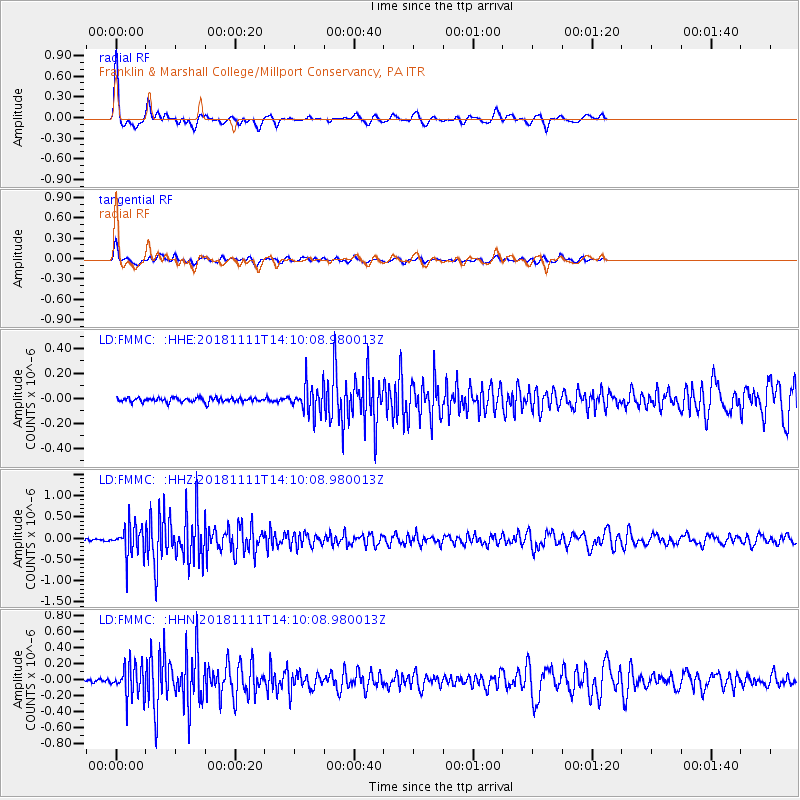
Signal To Noise
| Channel | StoN | STA | LTA |
| LD:FMMC: :HHZ:20181111T14:10:08.980013Z | 15.712973 | 3.5413476E-7 | 2.2537732E-8 |
| LD:FMMC: :HHN:20181111T14:10:08.980013Z | 7.917583 | 1.9099066E-7 | 2.4122345E-8 |
| LD:FMMC: :HHE:20181111T14:10:08.980013Z | 6.6672316 | 1.1480616E-7 | 1.7219465E-8 |
| Arrivals |
| Ps | 5.6 SECOND |
| PpPs | 15 SECOND |
| PsPs/PpSs | 21 SECOND |


