You are here: Home > Network List > LD - Lamont-Doherty Cooperative Seismographic Network Stations List
> Station PANJ Princeton, NJ > Earthquake Result Viewer
PANJ Princeton, NJ - Earthquake Result Viewer
| Earthquake location: |
North Atlantic Ocean |
| Earthquake latitude/longitude: |
15.6/-49.9 |
| Earthquake time(UTC): |
2018/11/11 (315) 14:03:59 GMT |
| Earthquake Depth: |
10 km |
| Earthquake Magnitude: |
6.2 mb |
| Earthquake Catalog/Contributor: |
NEIC PDE/us |
|
| Network: |
LD Lamont-Doherty Cooperative Seismographic Network |
| Station: |
PANJ Princeton, NJ |
| Lat/Lon: |
40.38 N/74.70 W |
| Elevation: |
100 m |
|
| Distance: |
32.8 deg |
| Az: |
323.715 deg |
| Baz: |
131.701 deg |
| Ray Param: |
0.0784818 |
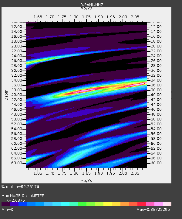
| Estimated Moho Depth: |
35.0 km |
| Estimated Crust Vp/Vs: |
2.09 |
| Assumed Crust Vp: |
6.283 km/s |
| Estimated Crust Vs: |
3.01 km/s |
| Estimated Crust Poisson's Ratio: |
0.35 |
|
| Radial Match: |
92.26176 % |
| Radial Bump: |
210 |
| Transverse Match: |
57.608223 % |
| Transverse Bump: |
338 |
| SOD ConfigId: |
13570011 |
| Insert Time: |
2019-05-01 19:20:47.622 +0000 |
| GWidth: |
2.5 |
| Max Bumps: |
400 |
| Tol: |
0.001 |
|
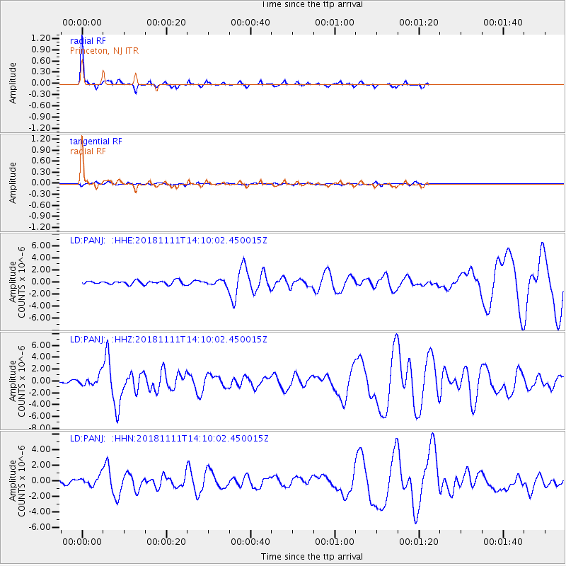
Signal To Noise
| Channel | StoN | STA | LTA |
| LD:PANJ: :HHZ:20181111T14:10:02.450015Z | 3.3729353 | 9.754691E-7 | 2.892048E-7 |
| LD:PANJ: :HHN:20181111T14:10:02.450015Z | 2.2820199 | 6.6784094E-7 | 2.9265343E-7 |
| LD:PANJ: :HHE:20181111T14:10:02.450015Z | 1.8702164 | 5.5735524E-7 | 2.9801643E-7 |
| Arrivals |
| Ps | 6.5 SECOND |
| PpPs | 16 SECOND |
| PsPs/PpSs | 23 SECOND |


