You are here: Home > Network List > LD - Lamont-Doherty Cooperative Seismographic Network Stations List
> Station WUPA West Chester University of Pennsylvania > Earthquake Result Viewer
WUPA West Chester University of Pennsylvania - Earthquake Result Viewer

| Earthquake location: |
North Atlantic Ocean |
| Earthquake latitude/longitude: |
15.6/-49.9 |
| Earthquake time(UTC): |
2018/11/11 (315) 14:03:59 GMT |
| Earthquake Depth: |
10 km |
| Earthquake Magnitude: |
6.2 mb |
| Earthquake Catalog/Contributor: |
NEIC PDE/us |
|
| Network: |
LD Lamont-Doherty Cooperative Seismographic Network |
| Station: |
WUPA West Chester University of Pennsylvania |
| Lat/Lon: |
39.93 N/75.61 W |
| Elevation: |
86 m |
|
| Distance: |
33.1 deg |
| Az: |
322.266 deg |
| Baz: |
129.904 deg |
| Ray Param: |
0.078377 |
| Estimated Moho Depth: |
40.0 km |
| Estimated Crust Vp/Vs: |
2.09 |
| Assumed Crust Vp: |
6.287 km/s |
| Estimated Crust Vs: |
3.005 km/s |
| Estimated Crust Poisson's Ratio: |
0.35 |
|
| Radial Match: |
84.286385 % |
| Radial Bump: |
360 |
| Transverse Match: |
66.33691 % |
| Transverse Bump: |
400 |
| SOD ConfigId: |
13570011 |
| Insert Time: |
2019-05-01 19:20:52.243 +0000 |
| GWidth: |
2.5 |
| Max Bumps: |
400 |
| Tol: |
0.001 |
|
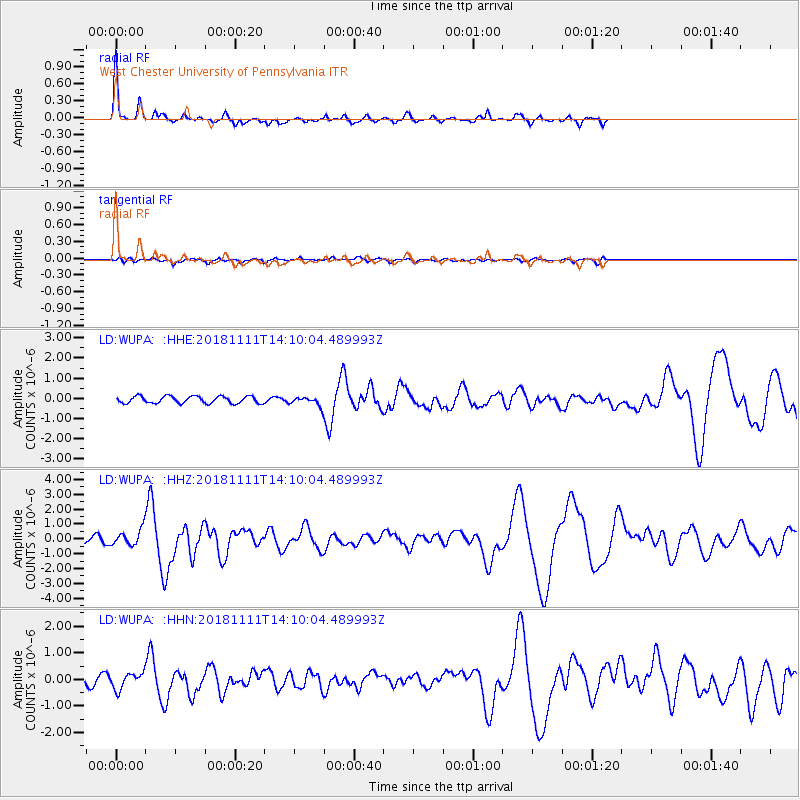
Signal To Noise
| Channel | StoN | STA | LTA |
| LD:WUPA: :HHZ:20181111T14:10:04.489993Z | 4.387953 | 5.9364E-7 | 1.352886E-7 |
| LD:WUPA: :HHN:20181111T14:10:04.489993Z | 1.3024412 | 3.14123E-7 | 2.4118017E-7 |
| LD:WUPA: :HHE:20181111T14:10:04.489993Z | 1.5844802 | 2.7240623E-7 | 1.7192151E-7 |
| Arrivals |
| Ps | 7.4 SECOND |
| PpPs | 18 SECOND |
| PsPs/PpSs | 26 SECOND |


