You are here: Home > Network List > MU - Miami University Seismic Network Stations List
> Station MUB2 Belmont > Earthquake Result Viewer
MUB2 Belmont - Earthquake Result Viewer
| Earthquake location: |
North Atlantic Ocean |
| Earthquake latitude/longitude: |
15.6/-49.9 |
| Earthquake time(UTC): |
2018/11/11 (315) 14:03:59 GMT |
| Earthquake Depth: |
10 km |
| Earthquake Magnitude: |
6.2 mb |
| Earthquake Catalog/Contributor: |
NEIC PDE/us |
|
| Network: |
MU Miami University Seismic Network |
| Station: |
MUB2 Belmont |
| Lat/Lon: |
40.08 N/80.90 W |
| Elevation: |
384 m |
|
| Distance: |
36.4 deg |
| Az: |
318.23 deg |
| Baz: |
123.195 deg |
| Ray Param: |
0.07668538 |
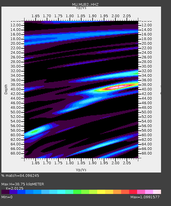
| Estimated Moho Depth: |
38.75 km |
| Estimated Crust Vp/Vs: |
2.01 |
| Assumed Crust Vp: |
6.483 km/s |
| Estimated Crust Vs: |
3.221 km/s |
| Estimated Crust Poisson's Ratio: |
0.34 |
|
| Radial Match: |
84.096245 % |
| Radial Bump: |
371 |
| Transverse Match: |
53.140907 % |
| Transverse Bump: |
400 |
| SOD ConfigId: |
13570011 |
| Insert Time: |
2019-05-01 19:21:02.361 +0000 |
| GWidth: |
2.5 |
| Max Bumps: |
400 |
| Tol: |
0.001 |
|

Signal To Noise
| Channel | StoN | STA | LTA |
| MU:MUB2: :HHZ:20181111T14:10:33.419985Z | 2.5049038 | 3.957798E-6 | 1.5800201E-6 |
| MU:MUB2: :HHN:20181111T14:10:33.419985Z | 1.0291673 | 1.4335656E-6 | 1.3929373E-6 |
| MU:MUB2: :HHE:20181111T14:10:33.419985Z | 0.86337537 | 1.4926701E-6 | 1.7288774E-6 |
| Arrivals |
| Ps | 6.5 SECOND |
| PpPs | 17 SECOND |
| PsPs/PpSs | 23 SECOND |


