You are here: Home > Network List > N4 - Central and EAstern US Network Stations List
> Station 250A Grady, AL, USA > Earthquake Result Viewer
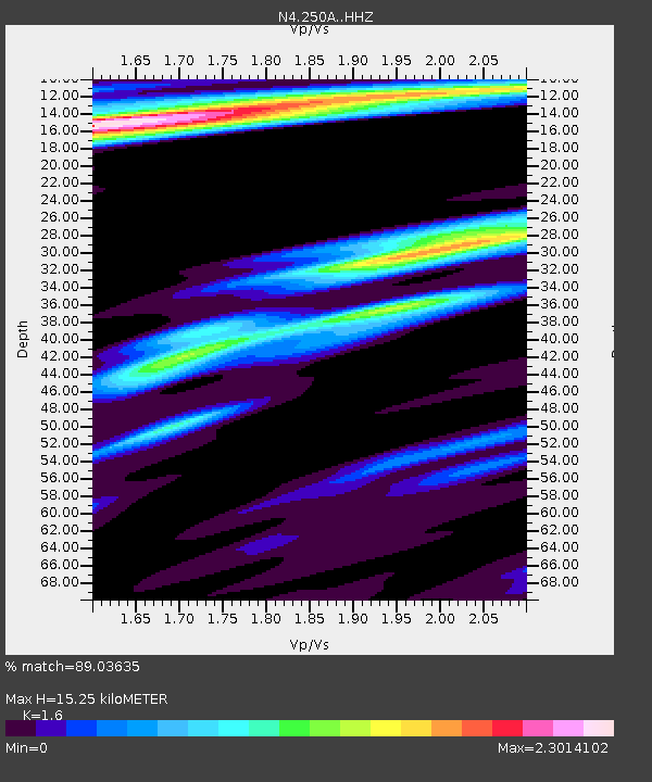
250A Grady, AL, USA - Earthquake Result Viewer
| Earthquake location: |
North Atlantic Ocean |
| Earthquake latitude/longitude: |
15.6/-49.9 |
| Earthquake time(UTC): |
2018/11/11 (315) 14:03:59 GMT |
| Earthquake Depth: |
10 km |
| Earthquake Magnitude: |
6.2 mb |
| Earthquake Catalog/Contributor: |
NEIC PDE/us |
|
| Network: |
N4 Central and EAstern US Network |
| Station: |
250A Grady, AL, USA |
| Lat/Lon: |
31.98 N/86.27 W |
| Elevation: |
152 m |
|
| Distance: |
36.9 deg |
| Az: |
302.845 deg |
| Baz: |
107.674 deg |
| Ray Param: |
0.07643241 |
| Estimated Moho Depth: |
15.25 km |
| Estimated Crust Vp/Vs: |
1.60 |
| Assumed Crust Vp: |
6.187 km/s |
| Estimated Crust Vs: |
3.867 km/s |
| Estimated Crust Poisson's Ratio: |
0.18 |
|
| Radial Match: |
89.03635 % |
| Radial Bump: |
297 |
| Transverse Match: |
66.71142 % |
| Transverse Bump: |
370 |
| SOD ConfigId: |
13570011 |
| Insert Time: |
2019-05-01 19:21:14.214 +0000 |
| GWidth: |
2.5 |
| Max Bumps: |
400 |
| Tol: |
0.001 |
|

Signal To Noise
| Channel | StoN | STA | LTA |
| N4:250A: :HHZ:20181111T14:10:37.369998Z | 12.902944 | 1.7482964E-6 | 1.3549594E-7 |
| N4:250A: :HHN:20181111T14:10:37.369998Z | 1.545274 | 4.712128E-7 | 3.0493803E-7 |
| N4:250A: :HHE:20181111T14:10:37.369998Z | 2.4304237 | 1.3209763E-6 | 5.435169E-7 |
| Arrivals |
| Ps | 1.6 SECOND |
| PpPs | 5.9 SECOND |
| PsPs/PpSs | 7.5 SECOND |


