You are here: Home > Network List > N4 - Central and EAstern US Network Stations List
> Station 352A Blakely, GA, USA > Earthquake Result Viewer
352A Blakely, GA, USA - Earthquake Result Viewer
| Earthquake location: |
North Atlantic Ocean |
| Earthquake latitude/longitude: |
15.6/-49.9 |
| Earthquake time(UTC): |
2018/11/11 (315) 14:03:59 GMT |
| Earthquake Depth: |
10 km |
| Earthquake Magnitude: |
6.2 mb |
| Earthquake Catalog/Contributor: |
NEIC PDE/us |
|
| Network: |
N4 Central and EAstern US Network |
| Station: |
352A Blakely, GA, USA |
| Lat/Lon: |
31.48 N/84.93 W |
| Elevation: |
101 m |
|
| Distance: |
35.7 deg |
| Az: |
302.641 deg |
| Baz: |
108.211 deg |
| Ray Param: |
0.07710706 |
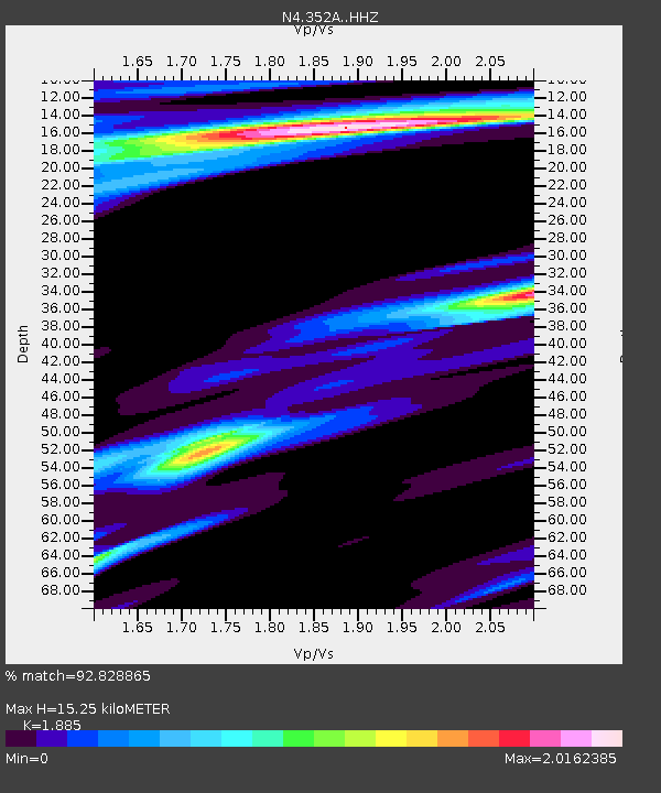
| Estimated Moho Depth: |
15.25 km |
| Estimated Crust Vp/Vs: |
1.88 |
| Assumed Crust Vp: |
6.347 km/s |
| Estimated Crust Vs: |
3.367 km/s |
| Estimated Crust Poisson's Ratio: |
0.30 |
|
| Radial Match: |
92.828865 % |
| Radial Bump: |
249 |
| Transverse Match: |
55.106445 % |
| Transverse Bump: |
309 |
| SOD ConfigId: |
13570011 |
| Insert Time: |
2019-05-01 19:21:15.147 +0000 |
| GWidth: |
2.5 |
| Max Bumps: |
400 |
| Tol: |
0.001 |
|

Signal To Noise
| Channel | StoN | STA | LTA |
| N4:352A: :HHZ:20181111T14:10:26.790011Z | 10.514542 | 2.829471E-6 | 2.6910075E-7 |
| N4:352A: :HHN:20181111T14:10:26.790011Z | 0.7906661 | 4.3470666E-7 | 5.49798E-7 |
| N4:352A: :HHE:20181111T14:10:26.790011Z | 2.9919674 | 1.5424334E-6 | 5.155248E-7 |
| Arrivals |
| Ps | 2.3 SECOND |
| PpPs | 6.5 SECOND |
| PsPs/PpSs | 8.7 SECOND |


