You are here: Home > Network List > N4 - Central and EAstern US Network Stations List
> Station BGNE Belgrade, NE, USA > Earthquake Result Viewer
BGNE Belgrade, NE, USA - Earthquake Result Viewer
| Earthquake location: |
North Atlantic Ocean |
| Earthquake latitude/longitude: |
15.6/-49.9 |
| Earthquake time(UTC): |
2018/11/11 (315) 14:03:59 GMT |
| Earthquake Depth: |
10 km |
| Earthquake Magnitude: |
6.2 mb |
| Earthquake Catalog/Contributor: |
NEIC PDE/us |
|
| Network: |
N4 Central and EAstern US Network |
| Station: |
BGNE Belgrade, NE, USA |
| Lat/Lon: |
41.41 N/98.15 W |
| Elevation: |
573 m |
|
| Distance: |
48.8 deg |
| Az: |
311.776 deg |
| Baz: |
107.151 deg |
| Ray Param: |
0.06908912 |
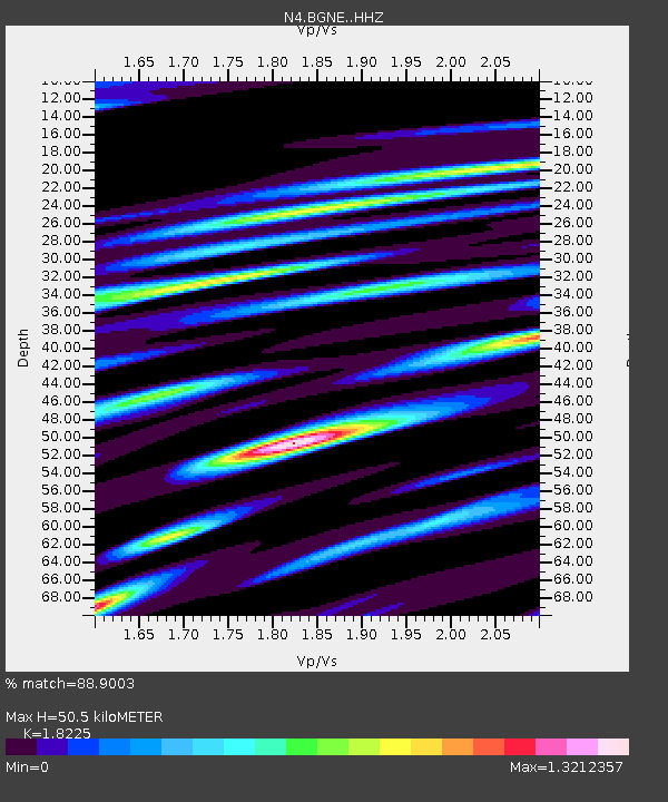
| Estimated Moho Depth: |
50.5 km |
| Estimated Crust Vp/Vs: |
1.82 |
| Assumed Crust Vp: |
6.53 km/s |
| Estimated Crust Vs: |
3.583 km/s |
| Estimated Crust Poisson's Ratio: |
0.28 |
|
| Radial Match: |
88.9003 % |
| Radial Bump: |
400 |
| Transverse Match: |
58.31527 % |
| Transverse Bump: |
400 |
| SOD ConfigId: |
13570011 |
| Insert Time: |
2019-05-01 19:21:21.859 +0000 |
| GWidth: |
2.5 |
| Max Bumps: |
400 |
| Tol: |
0.001 |
|

Signal To Noise
| Channel | StoN | STA | LTA |
| N4:BGNE: :HHZ:20181111T14:12:14.079989Z | 12.887904 | 2.519721E-6 | 1.9551054E-7 |
| N4:BGNE: :HHN:20181111T14:12:14.079989Z | 2.7250566 | 9.286736E-7 | 3.4079056E-7 |
| N4:BGNE: :HHE:20181111T14:12:14.079989Z | 4.8676753 | 2.0018804E-6 | 4.1126006E-7 |
| Arrivals |
| Ps | 6.8 SECOND |
| PpPs | 21 SECOND |
| PsPs/PpSs | 27 SECOND |


