You are here: Home > Network List > N4 - Central and EAstern US Network Stations List
> Station KMSC Kings Moutain, Blacksburg, SC, USA > Earthquake Result Viewer
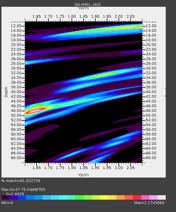
KMSC Kings Moutain, Blacksburg, SC, USA - Earthquake Result Viewer
| Earthquake location: |
North Atlantic Ocean |
| Earthquake latitude/longitude: |
15.6/-49.9 |
| Earthquake time(UTC): |
2018/11/11 (315) 14:03:59 GMT |
| Earthquake Depth: |
10 km |
| Earthquake Magnitude: |
6.2 mb |
| Earthquake Catalog/Contributor: |
NEIC PDE/us |
|
| Network: |
N4 Central and EAstern US Network |
| Station: |
KMSC Kings Moutain, Blacksburg, SC, USA |
| Lat/Lon: |
35.14 N/81.33 W |
| Elevation: |
240 m |
|
| Distance: |
34.3 deg |
| Az: |
310.54 deg |
| Baz: |
116.655 deg |
| Ray Param: |
0.07782803 |
| Estimated Moho Depth: |
47.75 km |
| Estimated Crust Vp/Vs: |
1.64 |
| Assumed Crust Vp: |
6.419 km/s |
| Estimated Crust Vs: |
3.908 km/s |
| Estimated Crust Poisson's Ratio: |
0.21 |
|
| Radial Match: |
81.832726 % |
| Radial Bump: |
267 |
| Transverse Match: |
59.81692 % |
| Transverse Bump: |
400 |
| SOD ConfigId: |
13570011 |
| Insert Time: |
2019-05-01 19:21:41.134 +0000 |
| GWidth: |
2.5 |
| Max Bumps: |
400 |
| Tol: |
0.001 |
|

Signal To Noise
| Channel | StoN | STA | LTA |
| N4:KMSC: :HHZ:20181111T14:10:14.810Z | 9.0471525 | 1.6961732E-6 | 1.8748143E-7 |
| N4:KMSC: :HHN:20181111T14:10:14.810Z | 4.648938 | 5.3109943E-7 | 1.1424101E-7 |
| N4:KMSC: :HHE:20181111T14:10:14.810Z | 4.9602747 | 1.183993E-6 | 2.3869504E-7 |
| Arrivals |
| Ps | 5.2 SECOND |
| PpPs | 18 SECOND |
| PsPs/PpSs | 23 SECOND |


