You are here: Home > Network List > TA - USArray Transportable Network (new EarthScope stations) Stations List
> Station 219A White Tail Canyon, San Simon, AZ, USA > Earthquake Result Viewer
219A White Tail Canyon, San Simon, AZ, USA - Earthquake Result Viewer
| Earthquake location: |
Andreanof Islands, Aleutian Is. |
| Earthquake latitude/longitude: |
52.2/-175.7 |
| Earthquake time(UTC): |
2008/08/07 (220) 18:30:03 GMT |
| Earthquake Depth: |
12 km |
| Earthquake Magnitude: |
5.6 MB, 5.5 MS, 5.8 MW, 5.8 MW |
| Earthquake Catalog/Contributor: |
WHDF/NEIC |
|
| Network: |
TA USArray Transportable Network (new EarthScope stations) |
| Station: |
219A White Tail Canyon, San Simon, AZ, USA |
| Lat/Lon: |
32.00 N/109.26 W |
| Elevation: |
1581 m |
|
| Distance: |
51.3 deg |
| Az: |
85.85 deg |
| Baz: |
313.726 deg |
| Ray Param: |
0.06748696 |
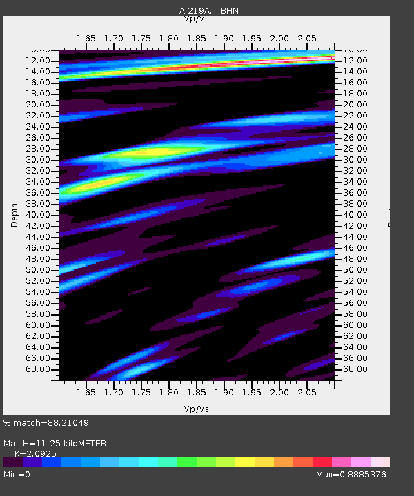
| Estimated Moho Depth: |
11.25 km |
| Estimated Crust Vp/Vs: |
2.09 |
| Assumed Crust Vp: |
6.182 km/s |
| Estimated Crust Vs: |
2.954 km/s |
| Estimated Crust Poisson's Ratio: |
0.35 |
|
| Radial Match: |
88.21049 % |
| Radial Bump: |
400 |
| Transverse Match: |
84.42218 % |
| Transverse Bump: |
400 |
| SOD ConfigId: |
2504 |
| Insert Time: |
2010-03-06 17:52:42.887 +0000 |
| GWidth: |
2.5 |
| Max Bumps: |
400 |
| Tol: |
0.001 |
|

Signal To Noise
| Channel | StoN | STA | LTA |
| TA:219A: :BHN:20080807T18:38:36.049004Z | 7.98746 | 3.705921E-7 | 4.639674E-8 |
| TA:219A: :BHE:20080807T18:38:36.049004Z | 3.2931204 | 1.3201677E-7 | 4.008865E-8 |
| TA:219A: :BHZ:20080807T18:38:36.049004Z | 2.7635412 | 1.039773E-7 | 3.762466E-8 |
| Arrivals |
| Ps | 2.1 SECOND |
| PpPs | 5.4 SECOND |
| PsPs/PpSs | 7.5 SECOND |


