You are here: Home > Network List > N4 - Central and EAstern US Network Stations List
> Station L48A N Adams, MI, USA > Earthquake Result Viewer
L48A N Adams, MI, USA - Earthquake Result Viewer
| Earthquake location: |
North Atlantic Ocean |
| Earthquake latitude/longitude: |
15.6/-49.9 |
| Earthquake time(UTC): |
2018/11/11 (315) 14:03:59 GMT |
| Earthquake Depth: |
10 km |
| Earthquake Magnitude: |
6.2 mb |
| Earthquake Catalog/Contributor: |
NEIC PDE/us |
|
| Network: |
N4 Central and EAstern US Network |
| Station: |
L48A N Adams, MI, USA |
| Lat/Lon: |
41.94 N/84.43 W |
| Elevation: |
369 m |
|
| Distance: |
39.7 deg |
| Az: |
318.476 deg |
| Baz: |
121.078 deg |
| Ray Param: |
0.07484414 |
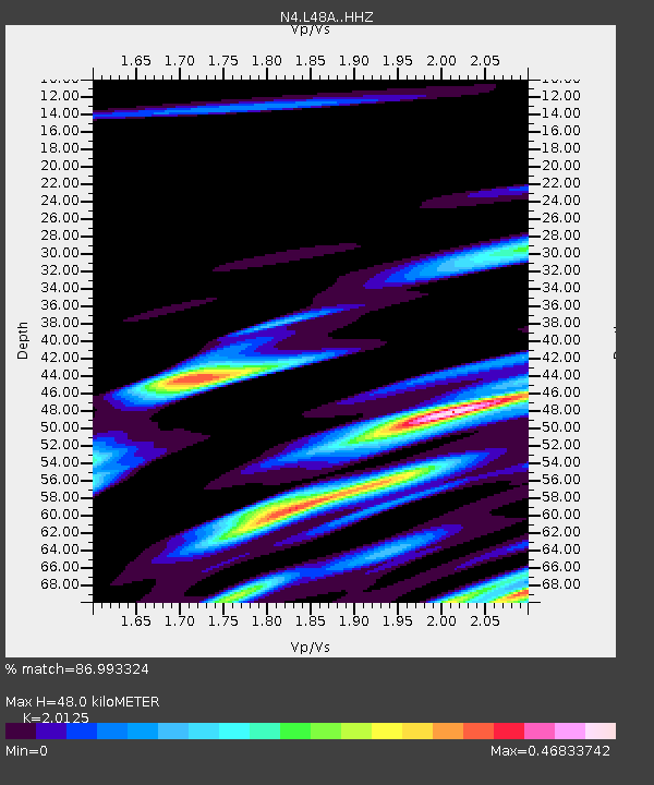
| Estimated Moho Depth: |
48.0 km |
| Estimated Crust Vp/Vs: |
2.01 |
| Assumed Crust Vp: |
6.498 km/s |
| Estimated Crust Vs: |
3.229 km/s |
| Estimated Crust Poisson's Ratio: |
0.34 |
|
| Radial Match: |
86.993324 % |
| Radial Bump: |
357 |
| Transverse Match: |
59.495712 % |
| Transverse Bump: |
400 |
| SOD ConfigId: |
13570011 |
| Insert Time: |
2019-05-01 19:21:46.147 +0000 |
| GWidth: |
2.5 |
| Max Bumps: |
400 |
| Tol: |
0.001 |
|

Signal To Noise
| Channel | StoN | STA | LTA |
| N4:L48A: :HHZ:20181111T14:11:00.79999Z | 4.3439507 | 1.7108355E-6 | 3.9384318E-7 |
| N4:L48A: :HHN:20181111T14:11:00.79999Z | 2.3831491 | 9.408693E-7 | 3.9480082E-7 |
| N4:L48A: :HHE:20181111T14:11:00.79999Z | 4.060915 | 9.955429E-7 | 2.4515234E-7 |
| Arrivals |
| Ps | 8.0 SECOND |
| PpPs | 21 SECOND |
| PsPs/PpSs | 29 SECOND |


