You are here: Home > Network List > N4 - Central and EAstern US Network Stations List
> Station P61A Hammonton, NJ, USA > Earthquake Result Viewer
P61A Hammonton, NJ, USA - Earthquake Result Viewer
| Earthquake location: |
North Atlantic Ocean |
| Earthquake latitude/longitude: |
15.6/-49.9 |
| Earthquake time(UTC): |
2018/11/11 (315) 14:03:59 GMT |
| Earthquake Depth: |
10 km |
| Earthquake Magnitude: |
6.2 mb |
| Earthquake Catalog/Contributor: |
NEIC PDE/us |
|
| Network: |
N4 Central and EAstern US Network |
| Station: |
P61A Hammonton, NJ, USA |
| Lat/Lon: |
39.67 N/74.79 W |
| Elevation: |
22 m |
|
| Distance: |
32.4 deg |
| Az: |
322.651 deg |
| Baz: |
130.748 deg |
| Ray Param: |
0.078656875 |
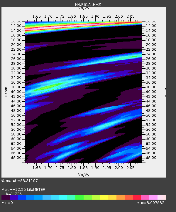
| Estimated Moho Depth: |
12.25 km |
| Estimated Crust Vp/Vs: |
1.74 |
| Assumed Crust Vp: |
6.287 km/s |
| Estimated Crust Vs: |
3.624 km/s |
| Estimated Crust Poisson's Ratio: |
0.25 |
|
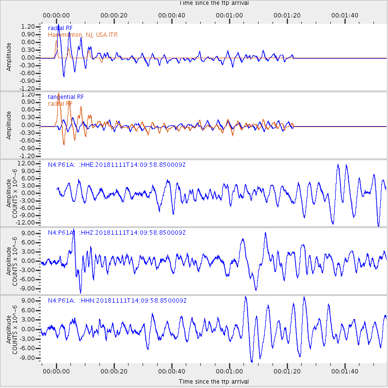
| Radial Match: |
88.31197 % |
| Radial Bump: |
336 |
| Transverse Match: |
68.41581 % |
| Transverse Bump: |
392 |
| SOD ConfigId: |
13570011 |
| Insert Time: |
2019-05-01 19:22:08.160 +0000 |
| GWidth: |
2.5 |
| Max Bumps: |
400 |
| Tol: |
0.001 |
|
Signal To Noise
| Channel | StoN | STA | LTA |
| N4:P61A: :HHZ:20181111T14:09:58.850009Z | 3.2275267 | 1.5162478E-6 | 4.697863E-7 |
| N4:P61A: :HHN:20181111T14:09:58.850009Z | 1.1998048 | 1.5294174E-6 | 1.274722E-6 |
| N4:P61A: :HHE:20181111T14:09:58.850009Z | 0.6791772 | 1.3944071E-6 | 2.0530829E-6 |
| Arrivals |
| Ps | 1.5 SECOND |
| PpPs | 4.9 SECOND |
| PsPs/PpSs | 6.5 SECOND |


