You are here: Home > Network List > TA - USArray Transportable Network (new EarthScope stations) Stations List
> Station 219A White Tail Canyon, San Simon, AZ, USA > Earthquake Result Viewer
219A White Tail Canyon, San Simon, AZ, USA - Earthquake Result Viewer
| Earthquake location: |
Central East Pacific Rise |
| Earthquake latitude/longitude: |
-9.0/-108.2 |
| Earthquake time(UTC): |
2008/10/30 (304) 15:15:41 GMT |
| Earthquake Depth: |
10 km |
| Earthquake Magnitude: |
5.5 MB, 5.8 MS, 6.0 MW, 6.0 MW |
| Earthquake Catalog/Contributor: |
WHDF/NEIC |
|
| Network: |
TA USArray Transportable Network (new EarthScope stations) |
| Station: |
219A White Tail Canyon, San Simon, AZ, USA |
| Lat/Lon: |
32.00 N/109.26 W |
| Elevation: |
1581 m |
|
| Distance: |
40.8 deg |
| Az: |
358.682 deg |
| Baz: |
178.468 deg |
| Ray Param: |
0.07418806 |
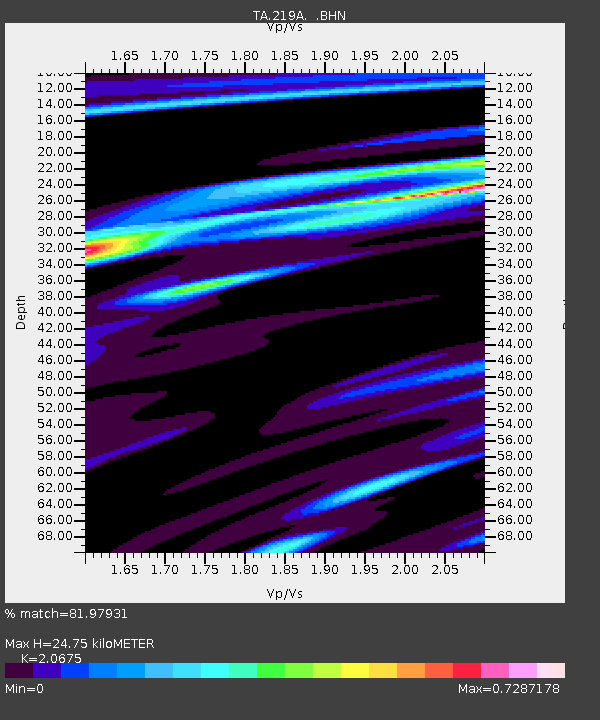
| Estimated Moho Depth: |
24.75 km |
| Estimated Crust Vp/Vs: |
2.07 |
| Assumed Crust Vp: |
6.182 km/s |
| Estimated Crust Vs: |
2.99 km/s |
| Estimated Crust Poisson's Ratio: |
0.35 |
|
| Radial Match: |
81.97931 % |
| Radial Bump: |
321 |
| Transverse Match: |
57.40922 % |
| Transverse Bump: |
400 |
| SOD ConfigId: |
2560 |
| Insert Time: |
2010-03-06 17:52:56.922 +0000 |
| GWidth: |
2.5 |
| Max Bumps: |
400 |
| Tol: |
0.001 |
|
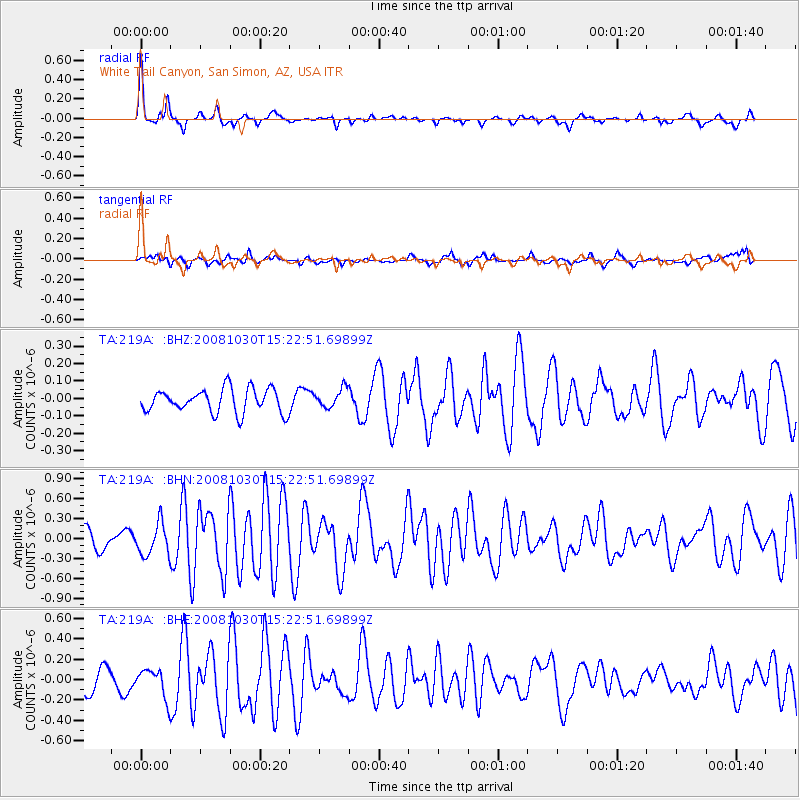
Signal To Noise
| Channel | StoN | STA | LTA |
| TA:219A: :BHN:20081030T15:22:51.69899Z | 1.4831233 | 2.3831444E-7 | 1.6068418E-7 |
| TA:219A: :BHE:20081030T15:22:51.69899Z | 1.5527048 | 1.4020888E-7 | 9.029977E-8 |
| TA:219A: :BHZ:20081030T15:22:51.69899Z | 0.79562205 | 5.4127515E-8 | 6.8031696E-8 |
| Arrivals |
| Ps | 4.5 SECOND |
| PpPs | 12 SECOND |
| PsPs/PpSs | 16 SECOND |


