You are here: Home > Network List > N4 - Central and EAstern US Network Stations List
> Station U56A King, NC, USA > Earthquake Result Viewer
U56A King, NC, USA - Earthquake Result Viewer
| Earthquake location: |
North Atlantic Ocean |
| Earthquake latitude/longitude: |
15.6/-49.9 |
| Earthquake time(UTC): |
2018/11/11 (315) 14:03:59 GMT |
| Earthquake Depth: |
10 km |
| Earthquake Magnitude: |
6.2 mb |
| Earthquake Catalog/Contributor: |
NEIC PDE/us |
|
| Network: |
N4 Central and EAstern US Network |
| Station: |
U56A King, NC, USA |
| Lat/Lon: |
36.35 N/80.38 W |
| Elevation: |
363 m |
|
| Distance: |
34.1 deg |
| Az: |
313.075 deg |
| Baz: |
119.304 deg |
| Ray Param: |
0.07788264 |
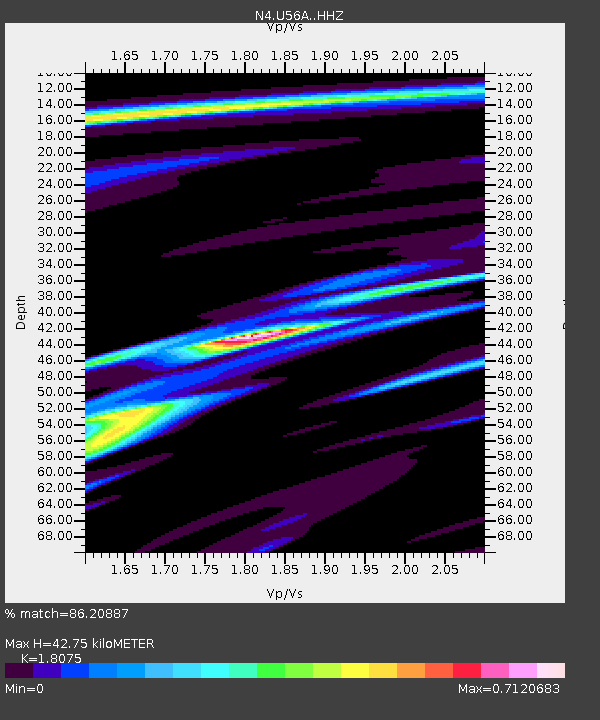
| Estimated Moho Depth: |
42.75 km |
| Estimated Crust Vp/Vs: |
1.81 |
| Assumed Crust Vp: |
6.159 km/s |
| Estimated Crust Vs: |
3.407 km/s |
| Estimated Crust Poisson's Ratio: |
0.28 |
|
| Radial Match: |
86.20887 % |
| Radial Bump: |
308 |
| Transverse Match: |
74.49654 % |
| Transverse Bump: |
400 |
| SOD ConfigId: |
13570011 |
| Insert Time: |
2019-05-01 19:22:29.850 +0000 |
| GWidth: |
2.5 |
| Max Bumps: |
400 |
| Tol: |
0.001 |
|

Signal To Noise
| Channel | StoN | STA | LTA |
| N4:U56A: :HHZ:20181111T14:10:13.790011Z | 11.512693 | 1.2835021E-6 | 1.11485825E-7 |
| N4:U56A: :HHN:20181111T14:10:13.790011Z | 2.0700731 | 5.542632E-7 | 2.6775055E-7 |
| N4:U56A: :HHE:20181111T14:10:13.790011Z | 4.413263 | 9.349097E-7 | 2.1184093E-7 |
| Arrivals |
| Ps | 6.0 SECOND |
| PpPs | 18 SECOND |
| PsPs/PpSs | 24 SECOND |


