You are here: Home > Network List > TA - USArray Transportable Network (new EarthScope stations) Stations List
> Station 219A White Tail Canyon, San Simon, AZ, USA > Earthquake Result Viewer
219A White Tail Canyon, San Simon, AZ, USA - Earthquake Result Viewer
| Earthquake location: |
Santa Cruz Islands Region |
| Earthquake latitude/longitude: |
-11.0/164.5 |
| Earthquake time(UTC): |
2008/07/19 (201) 09:27:01 GMT |
| Earthquake Depth: |
11 km |
| Earthquake Magnitude: |
6.1 MB, 6.4 MS, 6.6 MW, 6.6 MW |
| Earthquake Catalog/Contributor: |
WHDF/NEIC |
|
| Network: |
TA USArray Transportable Network (new EarthScope stations) |
| Station: |
219A White Tail Canyon, San Simon, AZ, USA |
| Lat/Lon: |
32.00 N/109.26 W |
| Elevation: |
1581 m |
|
| Distance: |
92.6 deg |
| Az: |
58.073 deg |
| Baz: |
258.711 deg |
| Ray Param: |
0.04142156 |
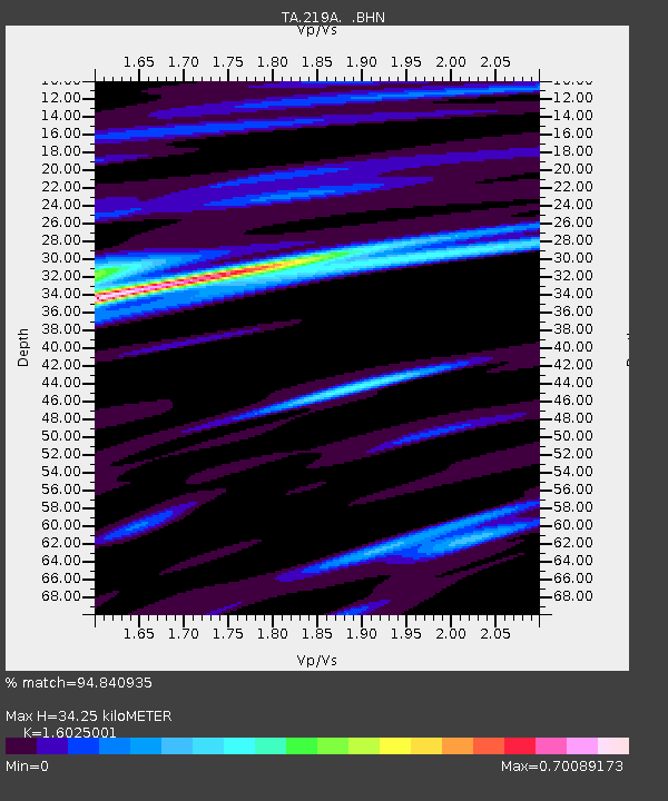
| Estimated Moho Depth: |
34.25 km |
| Estimated Crust Vp/Vs: |
1.60 |
| Assumed Crust Vp: |
6.182 km/s |
| Estimated Crust Vs: |
3.858 km/s |
| Estimated Crust Poisson's Ratio: |
0.18 |
|
| Radial Match: |
94.840935 % |
| Radial Bump: |
400 |
| Transverse Match: |
73.58259 % |
| Transverse Bump: |
400 |
| SOD ConfigId: |
2658 |
| Insert Time: |
2010-03-06 17:53:12.722 +0000 |
| GWidth: |
2.5 |
| Max Bumps: |
400 |
| Tol: |
0.001 |
|

Signal To Noise
| Channel | StoN | STA | LTA |
| TA:219A: :BHN:20080719T09:39:41.425027Z | 11.949986 | 9.831435E-7 | 8.227151E-8 |
| TA:219A: :BHE:20080719T09:39:41.425027Z | 2.2856238 | 1.2068479E-7 | 5.280168E-8 |
| TA:219A: :BHZ:20080719T09:39:41.425027Z | 2.569272 | 2.3258666E-7 | 9.052629E-8 |
| Arrivals |
| Ps | 3.4 SECOND |
| PpPs | 14 SECOND |
| PsPs/PpSs | 18 SECOND |


