You are here: Home > Network List > N4 - Central and EAstern US Network Stations List
> Station Z38B Mount Pleasant, TX, USA > Earthquake Result Viewer
Z38B Mount Pleasant, TX, USA - Earthquake Result Viewer
| Earthquake location: |
North Atlantic Ocean |
| Earthquake latitude/longitude: |
15.6/-49.9 |
| Earthquake time(UTC): |
2018/11/11 (315) 14:03:59 GMT |
| Earthquake Depth: |
10 km |
| Earthquake Magnitude: |
6.2 mb |
| Earthquake Catalog/Contributor: |
NEIC PDE/us |
|
| Network: |
N4 Central and EAstern US Network |
| Station: |
Z38B Mount Pleasant, TX, USA |
| Lat/Lon: |
33.26 N/94.99 W |
| Elevation: |
115 m |
|
| Distance: |
44.3 deg |
| Az: |
301.826 deg |
| Baz: |
102.215 deg |
| Ray Param: |
0.07198363 |
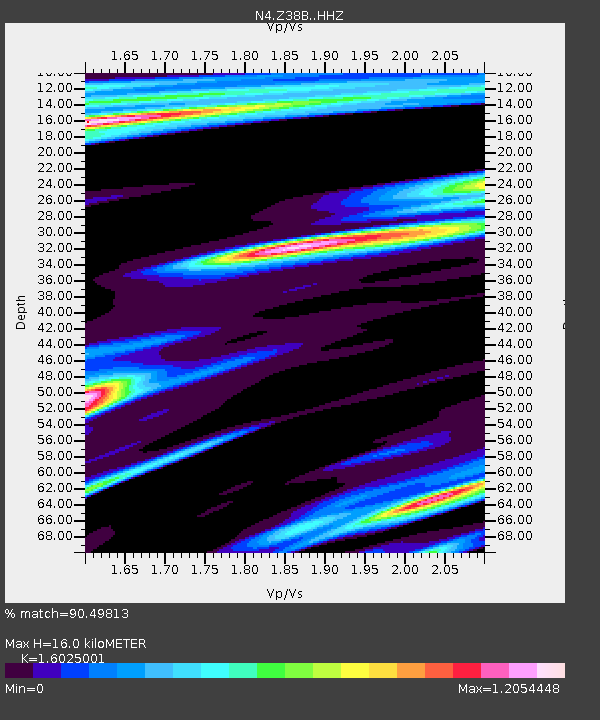
| Estimated Moho Depth: |
16.0 km |
| Estimated Crust Vp/Vs: |
1.60 |
| Assumed Crust Vp: |
6.245 km/s |
| Estimated Crust Vs: |
3.897 km/s |
| Estimated Crust Poisson's Ratio: |
0.18 |
|
| Radial Match: |
90.49813 % |
| Radial Bump: |
302 |
| Transverse Match: |
82.05966 % |
| Transverse Bump: |
400 |
| SOD ConfigId: |
13570011 |
| Insert Time: |
2019-05-01 19:22:44.861 +0000 |
| GWidth: |
2.5 |
| Max Bumps: |
400 |
| Tol: |
0.001 |
|

Signal To Noise
| Channel | StoN | STA | LTA |
| N4:Z38B: :HHZ:20181111T14:11:38.700015Z | 14.645765 | 3.5160567E-6 | 2.4007326E-7 |
| N4:Z38B: :HHN:20181111T14:11:38.700015Z | 1.8140056 | 3.4644412E-7 | 1.9098293E-7 |
| N4:Z38B: :HHE:20181111T14:11:38.700015Z | 2.071742 | 1.0500771E-6 | 5.068571E-7 |
| Arrivals |
| Ps | 1.7 SECOND |
| PpPs | 6.2 SECOND |
| PsPs/PpSs | 7.9 SECOND |


