You are here: Home > Network List > NM - Cooperative New Madrid Seismic Network Stations List
> Station BLO Bloomington, IN > Earthquake Result Viewer
BLO Bloomington, IN - Earthquake Result Viewer
| Earthquake location: |
North Atlantic Ocean |
| Earthquake latitude/longitude: |
15.6/-49.9 |
| Earthquake time(UTC): |
2018/11/11 (315) 14:03:59 GMT |
| Earthquake Depth: |
10 km |
| Earthquake Magnitude: |
6.2 mb |
| Earthquake Catalog/Contributor: |
NEIC PDE/us |
|
| Network: |
NM Cooperative New Madrid Seismic Network |
| Station: |
BLO Bloomington, IN |
| Lat/Lon: |
39.17 N/86.52 W |
| Elevation: |
246 m |
|
| Distance: |
39.8 deg |
| Az: |
313.479 deg |
| Baz: |
115.88 deg |
| Ray Param: |
0.074797384 |
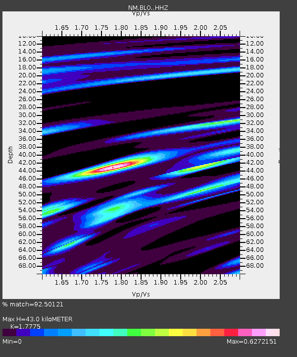
| Estimated Moho Depth: |
43.0 km |
| Estimated Crust Vp/Vs: |
1.78 |
| Assumed Crust Vp: |
6.444 km/s |
| Estimated Crust Vs: |
3.625 km/s |
| Estimated Crust Poisson's Ratio: |
0.27 |
|
| Radial Match: |
92.50121 % |
| Radial Bump: |
231 |
| Transverse Match: |
60.934414 % |
| Transverse Bump: |
400 |
| SOD ConfigId: |
13570011 |
| Insert Time: |
2019-05-01 19:22:51.739 +0000 |
| GWidth: |
2.5 |
| Max Bumps: |
400 |
| Tol: |
0.001 |
|

Signal To Noise
| Channel | StoN | STA | LTA |
| NM:BLO: :HHZ:20181111T14:11:01.459994Z | 4.525666 | 1.651461E-6 | 3.6491002E-7 |
| NM:BLO: :HHN:20181111T14:11:01.459994Z | 1.1722674 | 4.641747E-7 | 3.9596316E-7 |
| NM:BLO: :HHE:20181111T14:11:01.459994Z | 2.1115189 | 6.439618E-7 | 3.0497563E-7 |
| Arrivals |
| Ps | 5.6 SECOND |
| PpPs | 17 SECOND |
| PsPs/PpSs | 23 SECOND |


