You are here: Home > Network List > NM - Cooperative New Madrid Seismic Network Stations List
> Station MGMO Mountain Grove, MO > Earthquake Result Viewer
MGMO Mountain Grove, MO - Earthquake Result Viewer
| Earthquake location: |
North Atlantic Ocean |
| Earthquake latitude/longitude: |
15.6/-49.9 |
| Earthquake time(UTC): |
2018/11/11 (315) 14:03:59 GMT |
| Earthquake Depth: |
10 km |
| Earthquake Magnitude: |
6.2 mb |
| Earthquake Catalog/Contributor: |
NEIC PDE/us |
|
| Network: |
NM Cooperative New Madrid Seismic Network |
| Station: |
MGMO Mountain Grove, MO |
| Lat/Lon: |
37.15 N/92.27 W |
| Elevation: |
453 m |
|
| Distance: |
43.2 deg |
| Az: |
308.091 deg |
| Baz: |
108.303 deg |
| Ray Param: |
0.07270323 |
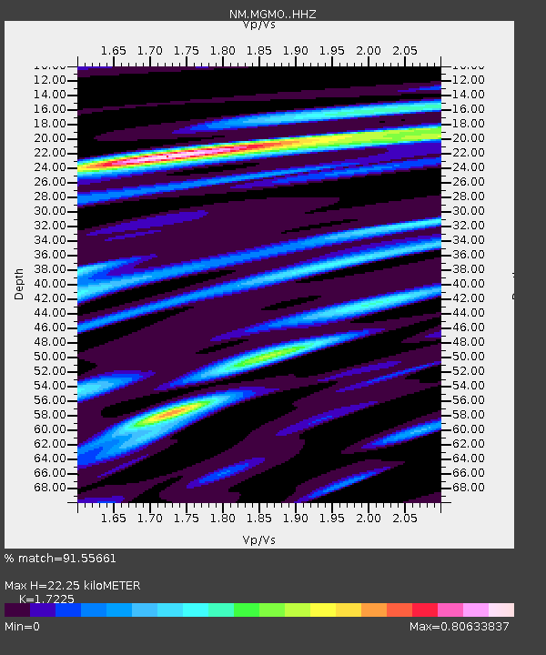
| Estimated Moho Depth: |
22.25 km |
| Estimated Crust Vp/Vs: |
1.72 |
| Assumed Crust Vp: |
6.53 km/s |
| Estimated Crust Vs: |
3.791 km/s |
| Estimated Crust Poisson's Ratio: |
0.25 |
|
| Radial Match: |
91.55661 % |
| Radial Bump: |
259 |
| Transverse Match: |
70.552086 % |
| Transverse Bump: |
333 |
| SOD ConfigId: |
13570011 |
| Insert Time: |
2019-05-01 19:22:53.220 +0000 |
| GWidth: |
2.5 |
| Max Bumps: |
400 |
| Tol: |
0.001 |
|

Signal To Noise
| Channel | StoN | STA | LTA |
| NM:MGMO: :HHZ:20181111T14:11:29.660006Z | 11.201368 | 2.124539E-6 | 1.896678E-7 |
| NM:MGMO: :HHN:20181111T14:11:29.660006Z | 3.1770155 | 6.043828E-7 | 1.9023602E-7 |
| NM:MGMO: :HHE:20181111T14:11:29.660006Z | 8.106053 | 1.209654E-6 | 1.4922847E-7 |
| Arrivals |
| Ps | 2.6 SECOND |
| PpPs | 8.6 SECOND |
| PsPs/PpSs | 11 SECOND |


