You are here: Home > Network List > TA - USArray Transportable Network (new EarthScope stations) Stations List
> Station 219A White Tail Canyon, San Simon, AZ, USA > Earthquake Result Viewer
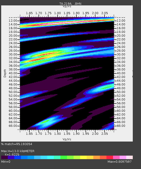
219A White Tail Canyon, San Simon, AZ, USA - Earthquake Result Viewer
| Earthquake location: |
Andreanof Islands, Aleutian Is. |
| Earthquake latitude/longitude: |
51.4/-179.5 |
| Earthquake time(UTC): |
2007/12/19 (353) 09:30:27 GMT |
| Earthquake Depth: |
29 km |
| Earthquake Magnitude: |
6.4 MB, 7.1 MS, 7.1 MW, 7.0 MW |
| Earthquake Catalog/Contributor: |
WHDF/NEIC |
|
| Network: |
TA USArray Transportable Network (new EarthScope stations) |
| Station: |
219A White Tail Canyon, San Simon, AZ, USA |
| Lat/Lon: |
32.00 N/109.26 W |
| Elevation: |
1581 m |
|
| Distance: |
53.8 deg |
| Az: |
82.374 deg |
| Baz: |
313.0 deg |
| Ray Param: |
0.06581093 |
| Estimated Moho Depth: |
13.0 km |
| Estimated Crust Vp/Vs: |
1.82 |
| Assumed Crust Vp: |
6.182 km/s |
| Estimated Crust Vs: |
3.392 km/s |
| Estimated Crust Poisson's Ratio: |
0.28 |
|
| Radial Match: |
95.193054 % |
| Radial Bump: |
309 |
| Transverse Match: |
77.60393 % |
| Transverse Bump: |
400 |
| SOD ConfigId: |
2564 |
| Insert Time: |
2010-03-06 17:53:19.105 +0000 |
| GWidth: |
2.5 |
| Max Bumps: |
400 |
| Tol: |
0.001 |
|

Signal To Noise
| Channel | StoN | STA | LTA |
| TA:219A: :BHN:20071219T09:39:16.299001Z | 3.196174 | 7.039512E-7 | 2.2024808E-7 |
| TA:219A: :BHE:20071219T09:39:16.299001Z | 2.6563885 | 8.7601916E-7 | 3.2977826E-7 |
| TA:219A: :BHZ:20071219T09:39:16.299001Z | 3.6061046 | 2.4315814E-6 | 6.7429585E-7 |
| Arrivals |
| Ps | 1.8 SECOND |
| PpPs | 5.7 SECOND |
| PsPs/PpSs | 7.5 SECOND |


