You are here: Home > Network List > O2 - Oklahoma Consolidated Temporary Seismic Networks Stations List
> Station CHAN Chandler, Oklahoma, USA > Earthquake Result Viewer
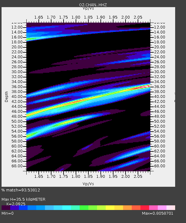
CHAN Chandler, Oklahoma, USA - Earthquake Result Viewer
| Earthquake location: |
North Atlantic Ocean |
| Earthquake latitude/longitude: |
15.6/-49.9 |
| Earthquake time(UTC): |
2018/11/11 (315) 14:03:59 GMT |
| Earthquake Depth: |
10 km |
| Earthquake Magnitude: |
6.2 mb |
| Earthquake Catalog/Contributor: |
NEIC PDE/us |
|
| Network: |
O2 Oklahoma Consolidated Temporary Seismic Networks |
| Station: |
CHAN Chandler, Oklahoma, USA |
| Lat/Lon: |
35.65 N/96.79 W |
| Elevation: |
266 m |
|
| Distance: |
46.3 deg |
| Az: |
304.641 deg |
| Baz: |
103.181 deg |
| Ray Param: |
0.07072632 |
| Estimated Moho Depth: |
35.5 km |
| Estimated Crust Vp/Vs: |
2.09 |
| Assumed Crust Vp: |
6.426 km/s |
| Estimated Crust Vs: |
3.071 km/s |
| Estimated Crust Poisson's Ratio: |
0.35 |
|
| Radial Match: |
93.53812 % |
| Radial Bump: |
381 |
| Transverse Match: |
75.054985 % |
| Transverse Bump: |
400 |
| SOD ConfigId: |
13570011 |
| Insert Time: |
2019-05-01 19:23:37.185 +0000 |
| GWidth: |
2.5 |
| Max Bumps: |
400 |
| Tol: |
0.001 |
|

Signal To Noise
| Channel | StoN | STA | LTA |
| O2:CHAN: :HHZ:20181111T14:11:54.363986Z | 14.8493805 | 3.7049267E-6 | 2.4950043E-7 |
| O2:CHAN: :HH1:20181111T14:11:54.363986Z | 1.7963504 | 6.2827075E-7 | 3.4974843E-7 |
| O2:CHAN: :HH2:20181111T14:11:54.363986Z | 7.384123 | 1.8405743E-6 | 2.4926106E-7 |
| Arrivals |
| Ps | 6.4 SECOND |
| PpPs | 16 SECOND |
| PsPs/PpSs | 23 SECOND |


