You are here: Home > Network List > TS - TERRAscope (Southern California Seismic Network) Stations List
> Station BAR Barrett Dam, California, USA > Earthquake Result Viewer
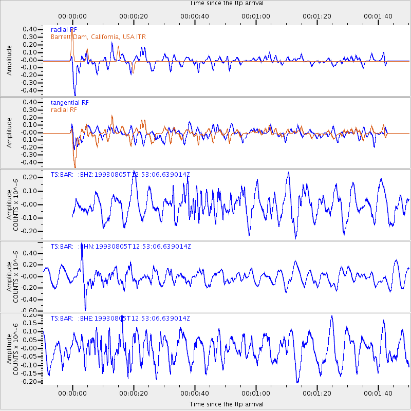
BAR Barrett Dam, California, USA - Earthquake Result Viewer
*The percent match for this event was below the threshold and hence no stack was calculated.
| Earthquake location: |
Fiji Islands Region |
| Earthquake latitude/longitude: |
-18.0/-178.4 |
| Earthquake time(UTC): |
1993/08/05 (217) 12:42:43 GMT |
| Earthquake Depth: |
616 km |
| Earthquake Magnitude: |
5.5 MB, 5.2 UNKNOWN |
| Earthquake Catalog/Contributor: |
WHDF/NEIC |
|
| Network: |
TS TERRAscope (Southern California Seismic Network) |
| Station: |
BAR Barrett Dam, California, USA |
| Lat/Lon: |
32.68 N/116.67 W |
| Elevation: |
548 m |
|
| Distance: |
77.5 deg |
| Az: |
49.501 deg |
| Baz: |
239.11 deg |
| Ray Param: |
$rayparam |
*The percent match for this event was below the threshold and hence was not used in the summary stack. |
|
| Radial Match: |
74.32783 % |
| Radial Bump: |
400 |
| Transverse Match: |
60.76491 % |
| Transverse Bump: |
400 |
| SOD ConfigId: |
4480 |
| Insert Time: |
2010-02-26 14:00:30.922 +0000 |
| GWidth: |
2.5 |
| Max Bumps: |
400 |
| Tol: |
0.001 |
|
Signal To Noise
| Channel | StoN | STA | LTA |
| TS:BAR: :BHN:19930805T12:53:06.639014Z | 1.9615481 | 2.3087568E-7 | 1.1770075E-7 |
| TS:BAR: :BHE:19930805T12:53:06.639014Z | 0.778341 | 5.439614E-8 | 6.9887285E-8 |
| TS:BAR: :BHZ:19930805T12:53:06.639014Z | 0.8649949 | 7.639439E-8 | 8.831774E-8 |
| Arrivals |
| Ps | |
| PpPs | |
| PsPs/PpSs | |


