You are here: Home > Network List > TA - USArray Transportable Network (new EarthScope stations) Stations List
> Station 219A White Tail Canyon, San Simon, AZ, USA > Earthquake Result Viewer
219A White Tail Canyon, San Simon, AZ, USA - Earthquake Result Viewer
| Earthquake location: |
Near Coast Of Northern Chile |
| Earthquake latitude/longitude: |
-23.1/-70.6 |
| Earthquake time(UTC): |
2007/11/17 (321) 17:54:32 GMT |
| Earthquake Depth: |
15 km |
| Earthquake Magnitude: |
5.6 MB, 5.6 MS, 5.8 MW, 5.8 MW |
| Earthquake Catalog/Contributor: |
WHDF/NEIC |
|
| Network: |
TA USArray Transportable Network (new EarthScope stations) |
| Station: |
219A White Tail Canyon, San Simon, AZ, USA |
| Lat/Lon: |
32.00 N/109.26 W |
| Elevation: |
1581 m |
|
| Distance: |
66.1 deg |
| Az: |
324.498 deg |
| Baz: |
140.985 deg |
| Ray Param: |
0.05785024 |
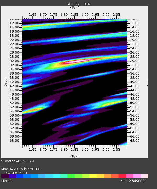
| Estimated Moho Depth: |
29.75 km |
| Estimated Crust Vp/Vs: |
1.87 |
| Assumed Crust Vp: |
6.182 km/s |
| Estimated Crust Vs: |
3.31 km/s |
| Estimated Crust Poisson's Ratio: |
0.30 |
|
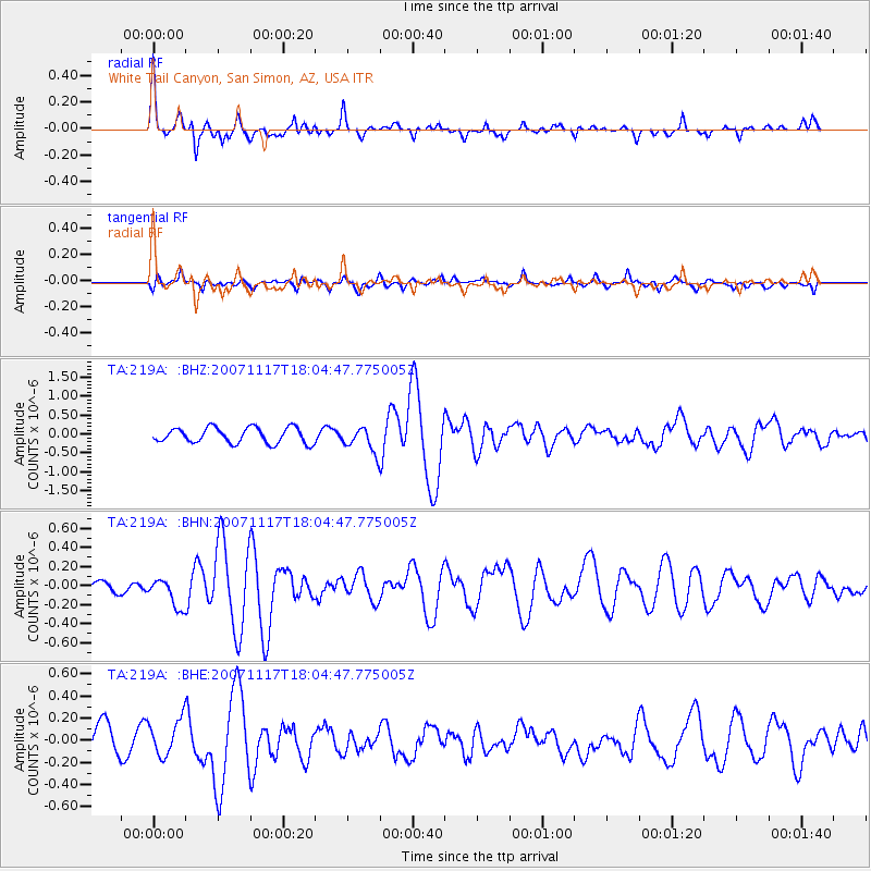
| Radial Match: |
82.95379 % |
| Radial Bump: |
377 |
| Transverse Match: |
47.81061 % |
| Transverse Bump: |
381 |
| SOD ConfigId: |
2564 |
| Insert Time: |
2010-03-06 17:53:32.709 +0000 |
| GWidth: |
2.5 |
| Max Bumps: |
400 |
| Tol: |
0.001 |
|
Signal To Noise
| Channel | StoN | STA | LTA |
| TA:219A: :BHN:20071117T18:04:47.775005Z | 1.1688794 | 1.515417E-7 | 1.2964699E-7 |
| TA:219A: :BHE:20071117T18:04:47.775005Z | 1.0847148 | 1.6860999E-7 | 1.5544178E-7 |
| TA:219A: :BHZ:20071117T18:04:47.775005Z | 1.625264 | 3.3005682E-7 | 2.0307888E-7 |
| Arrivals |
| Ps | 4.3 SECOND |
| PpPs | 13 SECOND |
| PsPs/PpSs | 18 SECOND |


