You are here: Home > Network List > OK - Oklahoma Seismic Network Stations List
> Station ELIS Ellis County, Oklahoma > Earthquake Result Viewer
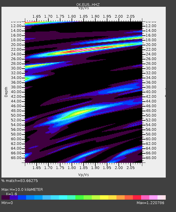
ELIS Ellis County, Oklahoma - Earthquake Result Viewer
| Earthquake location: |
North Atlantic Ocean |
| Earthquake latitude/longitude: |
15.6/-49.9 |
| Earthquake time(UTC): |
2018/11/11 (315) 14:03:59 GMT |
| Earthquake Depth: |
10 km |
| Earthquake Magnitude: |
6.2 mb |
| Earthquake Catalog/Contributor: |
NEIC PDE/us |
|
| Network: |
OK Oklahoma Seismic Network |
| Station: |
ELIS Ellis County, Oklahoma |
| Lat/Lon: |
36.07 N/99.42 W |
| Elevation: |
641 m |
|
| Distance: |
48.5 deg |
| Az: |
304.563 deg |
| Baz: |
101.593 deg |
| Ray Param: |
0.06933261 |
| Estimated Moho Depth: |
10.0 km |
| Estimated Crust Vp/Vs: |
1.60 |
| Assumed Crust Vp: |
6.426 km/s |
| Estimated Crust Vs: |
4.016 km/s |
| Estimated Crust Poisson's Ratio: |
0.18 |
|
| Radial Match: |
83.66275 % |
| Radial Bump: |
400 |
| Transverse Match: |
58.06032 % |
| Transverse Bump: |
400 |
| SOD ConfigId: |
13570011 |
| Insert Time: |
2019-05-01 19:23:52.319 +0000 |
| GWidth: |
2.5 |
| Max Bumps: |
400 |
| Tol: |
0.001 |
|

Signal To Noise
| Channel | StoN | STA | LTA |
| OK:ELIS: :HHZ:20181111T14:12:11.283999Z | 7.6723967 | 4.0931827E-6 | 5.3349464E-7 |
| OK:ELIS: :HHN:20181111T14:12:11.283999Z | 1.0530142 | 7.497267E-7 | 7.119816E-7 |
| OK:ELIS: :HHE:20181111T14:12:11.283999Z | 2.708852 | 1.6855371E-6 | 6.2223296E-7 |
| Arrivals |
| Ps | 1.0 SECOND |
| PpPs | 3.8 SECOND |
| PsPs/PpSs | 4.8 SECOND |


