You are here: Home > Network List > OK - Oklahoma Seismic Network Stations List
> Station MOOR Moore, Oklahoma, USA > Earthquake Result Viewer
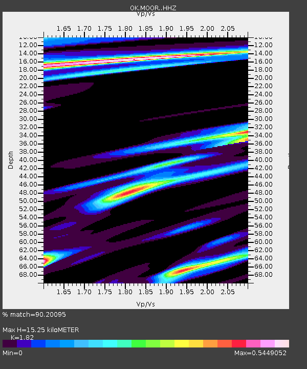
MOOR Moore, Oklahoma, USA - Earthquake Result Viewer
| Earthquake location: |
North Atlantic Ocean |
| Earthquake latitude/longitude: |
15.6/-49.9 |
| Earthquake time(UTC): |
2018/11/11 (315) 14:03:59 GMT |
| Earthquake Depth: |
10 km |
| Earthquake Magnitude: |
6.2 mb |
| Earthquake Catalog/Contributor: |
NEIC PDE/us |
|
| Network: |
OK Oklahoma Seismic Network |
| Station: |
MOOR Moore, Oklahoma, USA |
| Lat/Lon: |
35.34 N/97.66 W |
| Elevation: |
371 m |
|
| Distance: |
46.9 deg |
| Az: |
304.008 deg |
| Baz: |
102.241 deg |
| Ray Param: |
0.07032644 |
| Estimated Moho Depth: |
15.25 km |
| Estimated Crust Vp/Vs: |
1.82 |
| Assumed Crust Vp: |
6.426 km/s |
| Estimated Crust Vs: |
3.531 km/s |
| Estimated Crust Poisson's Ratio: |
0.28 |
|
| Radial Match: |
90.20095 % |
| Radial Bump: |
400 |
| Transverse Match: |
67.53024 % |
| Transverse Bump: |
400 |
| SOD ConfigId: |
13570011 |
| Insert Time: |
2019-05-01 19:23:56.011 +0000 |
| GWidth: |
2.5 |
| Max Bumps: |
400 |
| Tol: |
0.001 |
|

Signal To Noise
| Channel | StoN | STA | LTA |
| OK:MOOR: :HHZ:20181111T14:11:59.273989Z | 10.699301 | 4.1315043E-6 | 3.8614715E-7 |
| OK:MOOR: :HHN:20181111T14:11:59.273989Z | 0.8276979 | 5.053562E-7 | 6.1055636E-7 |
| OK:MOOR: :HHE:20181111T14:11:59.273989Z | 3.178883 | 1.6170245E-6 | 5.086769E-7 |
| Arrivals |
| Ps | 2.1 SECOND |
| PpPs | 6.3 SECOND |
| PsPs/PpSs | 8.4 SECOND |


