You are here: Home > Network List > TA - USArray Transportable Network (new EarthScope stations) Stations List
> Station 219A White Tail Canyon, San Simon, AZ, USA > Earthquake Result Viewer
219A White Tail Canyon, San Simon, AZ, USA - Earthquake Result Viewer
| Earthquake location: |
Near Coast Of Peru |
| Earthquake latitude/longitude: |
-13.3/-76.5 |
| Earthquake time(UTC): |
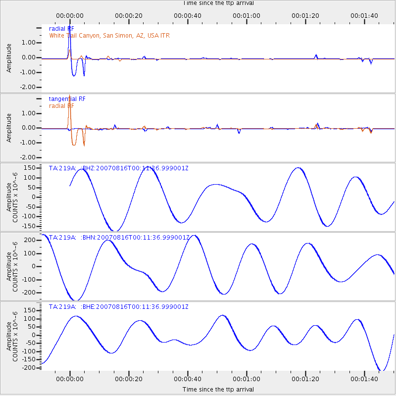
2007/08/16 (228) 00:02:41 GMT |
| Earthquake Depth: |
40 km |
| Earthquake Magnitude: |
5.6 MB |
| Earthquake Catalog/Contributor: |
WHDF/NEIC |
|
| Network: |
TA USArray Transportable Network (new EarthScope stations) |
| Station: |
219A White Tail Canyon, San Simon, AZ, USA |
| Lat/Lon: |
32.00 N/109.26 W |
| Elevation: |
1581 m |
|
| Distance: |
54.9 deg |
| Az: |
325.782 deg |
| Baz: |
139.875 deg |
| Ray Param: |
0.06508943 |
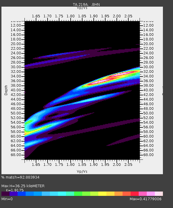
| Estimated Moho Depth: |
36.25 km |
| Estimated Crust Vp/Vs: |
1.92 |
| Assumed Crust Vp: |
6.182 km/s |
| Estimated Crust Vs: |
3.224 km/s |
| Estimated Crust Poisson's Ratio: |
0.31 |
|
| Radial Match: |
92.883934 % |
| Radial Bump: |
376 |
| Transverse Match: |
55.58804 % |
| Transverse Bump: |
271 |
| SOD ConfigId: |
2564 |
| Insert Time: |
2010-03-06 17:53:49.048 +0000 |
| GWidth: |
2.5 |
| Max Bumps: |
400 |
| Tol: |
0.001 |
|
Signal To Noise
| Channel | StoN | STA | LTA |
| TA:219A: :BHN:20070816T00:11:36.999001Z | 1.8227499 | 2.6592062E-4 | 1.458898E-4 |
| TA:219A: :BHE:20070816T00:11:36.999001Z | 1.1196036 | 1.208886E-4 | 1.0797446E-4 |
| TA:219A: :BHZ:20070816T00:11:36.999001Z | 0.6243943 | 7.1334805E-5 | 1.142464E-4 |
| Arrivals |
| Ps | 5.6 SECOND |
| PpPs | 16 SECOND |
| PsPs/PpSs | 22 SECOND |


