You are here: Home > Network List > RV - Regional Alberta Seismic Observatory for Earthquake Studies Network Stations List
> Station YELLA Yellowhead Lookout Tower, AB > Earthquake Result Viewer
YELLA Yellowhead Lookout Tower, AB - Earthquake Result Viewer
| Earthquake location: |
North Atlantic Ocean |
| Earthquake latitude/longitude: |
15.6/-49.9 |
| Earthquake time(UTC): |
2018/11/11 (315) 14:03:59 GMT |
| Earthquake Depth: |
10 km |
| Earthquake Magnitude: |
6.2 mb |
| Earthquake Catalog/Contributor: |
NEIC PDE/us |
|
| Network: |
RV Regional Alberta Seismic Observatory for Earthquake Studies Network |
| Station: |
YELLA Yellowhead Lookout Tower, AB |
| Lat/Lon: |
53.24 N/117.14 W |
| Elevation: |
1478 m |
|
| Distance: |
64.1 deg |
| Az: |
321.949 deg |
| Baz: |
98.778 deg |
| Ray Param: |
0.059143722 |
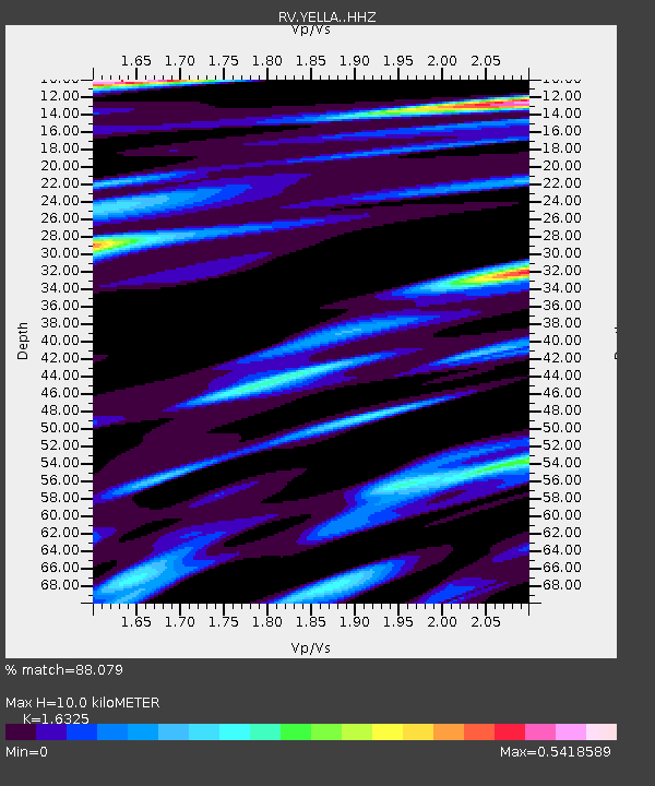
| Estimated Moho Depth: |
10.0 km |
| Estimated Crust Vp/Vs: |
1.63 |
| Assumed Crust Vp: |
6.142 km/s |
| Estimated Crust Vs: |
3.762 km/s |
| Estimated Crust Poisson's Ratio: |
0.20 |
|
| Radial Match: |
88.079 % |
| Radial Bump: |
400 |
| Transverse Match: |
76.09307 % |
| Transverse Bump: |
400 |
| SOD ConfigId: |
13570011 |
| Insert Time: |
2019-05-01 19:25:29.942 +0000 |
| GWidth: |
2.5 |
| Max Bumps: |
400 |
| Tol: |
0.001 |
|

Signal To Noise
| Channel | StoN | STA | LTA |
| RV:YELLA: :HHZ:20181111T14:14:02.520022Z | 7.226618 | 3.824103E-6 | 5.2916914E-7 |
| RV:YELLA: :HHN:20181111T14:14:02.520022Z | 2.0086384 | 3.6017803E-7 | 1.7931451E-7 |
| RV:YELLA: :HHE:20181111T14:14:02.520022Z | 5.3195796 | 1.0794006E-6 | 2.0291087E-7 |
| Arrivals |
| Ps | 1.1 SECOND |
| PpPs | 4.1 SECOND |
| PsPs/PpSs | 5.2 SECOND |


