You are here: Home > Network List > TA - USArray Transportable Network (new EarthScope stations) Stations List
> Station 219A White Tail Canyon, San Simon, AZ, USA > Earthquake Result Viewer
219A White Tail Canyon, San Simon, AZ, USA - Earthquake Result Viewer
| Earthquake location: |
Near Coast Of Central Chile |
| Earthquake latitude/longitude: |
-32.0/-71.3 |
| Earthquake time(UTC): |
2007/06/28 (179) 19:25:21 GMT |
| Earthquake Depth: |
69 km |
| Earthquake Magnitude: |
5.5 MB, 5.7 MW, 5.6 MW |
| Earthquake Catalog/Contributor: |
WHDF/NEIC |
|
| Network: |
TA USArray Transportable Network (new EarthScope stations) |
| Station: |
219A White Tail Canyon, San Simon, AZ, USA |
| Lat/Lon: |
32.00 N/109.26 W |
| Elevation: |
1581 m |
|
| Distance: |
73.1 deg |
| Az: |
326.919 deg |
| Baz: |
146.921 deg |
| Ray Param: |
0.053103194 |
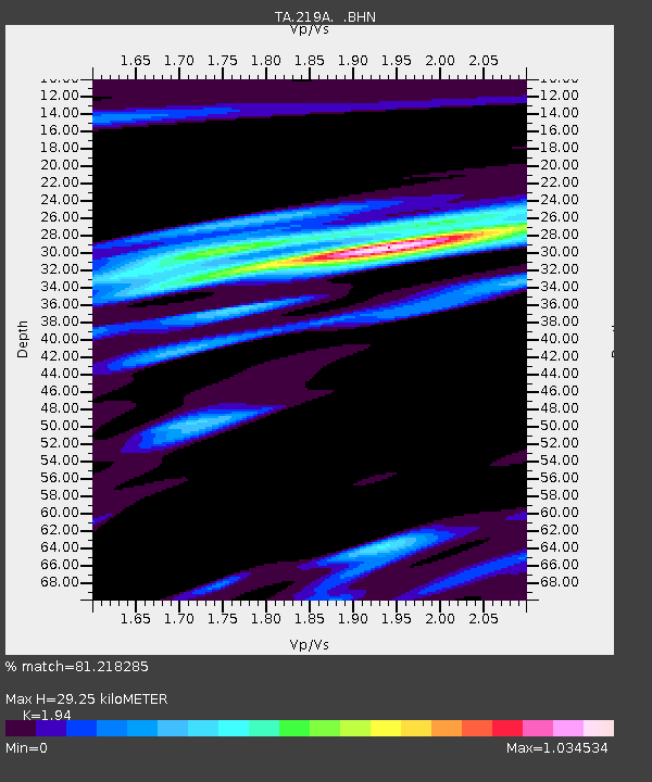
| Estimated Moho Depth: |
29.25 km |
| Estimated Crust Vp/Vs: |
1.94 |
| Assumed Crust Vp: |
6.182 km/s |
| Estimated Crust Vs: |
3.187 km/s |
| Estimated Crust Poisson's Ratio: |
0.32 |
|
| Radial Match: |
81.218285 % |
| Radial Bump: |
384 |
| Transverse Match: |
68.97833 % |
| Transverse Bump: |
400 |
| SOD ConfigId: |
2564 |
| Insert Time: |
2010-03-06 17:54:18.707 +0000 |
| GWidth: |
2.5 |
| Max Bumps: |
400 |
| Tol: |
0.001 |
|

Signal To Noise
| Channel | StoN | STA | LTA |
| TA:219A: :BHN:20070628T19:36:13.174016Z | 4.2130747 | 1.420292E-7 | 3.371153E-8 |
| TA:219A: :BHE:20070628T19:36:13.174016Z | 3.0675464 | 1.1874594E-7 | 3.8710397E-8 |
| TA:219A: :BHZ:20070628T19:36:13.174016Z | 8.537661 | 4.5668125E-7 | 5.3490208E-8 |
| Arrivals |
| Ps | 4.6 SECOND |
| PpPs | 14 SECOND |
| PsPs/PpSs | 18 SECOND |


