You are here: Home > Network List > TA - USArray Transportable Network (new EarthScope stations) Stations List
> Station G21K Allakaket, AK, USA > Earthquake Result Viewer
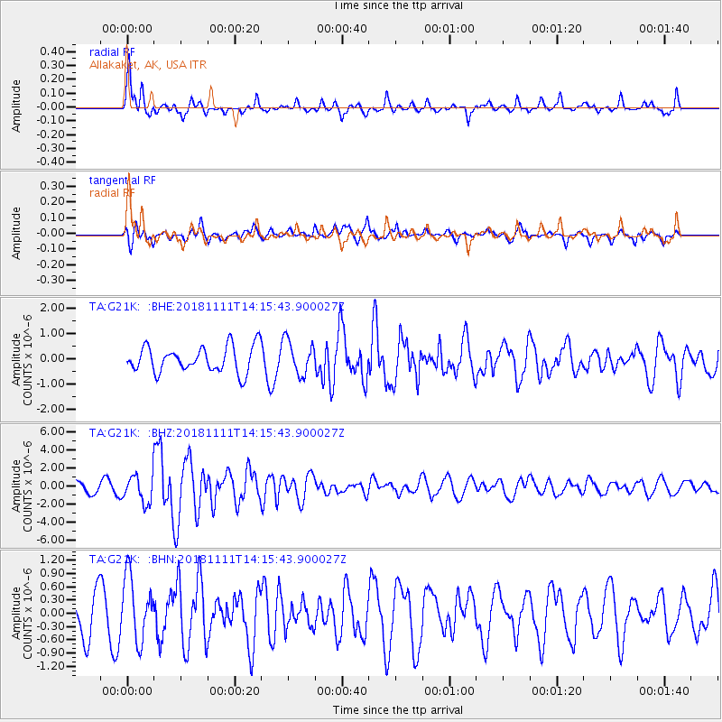
G21K Allakaket, AK, USA - Earthquake Result Viewer
*The percent match for this event was below the threshold and hence no stack was calculated.
| Earthquake location: |
North Atlantic Ocean |
| Earthquake latitude/longitude: |
15.6/-49.9 |
| Earthquake time(UTC): |
2018/11/11 (315) 14:03:59 GMT |
| Earthquake Depth: |
10 km |
| Earthquake Magnitude: |
6.2 mb |
| Earthquake Catalog/Contributor: |
NEIC PDE/us |
|
| Network: |
TA USArray Transportable Network (new EarthScope stations) |
| Station: |
G21K Allakaket, AK, USA |
| Lat/Lon: |
66.52 N/153.51 W |
| Elevation: |
446 m |
|
| Distance: |
81.2 deg |
| Az: |
336.79 deg |
| Baz: |
71.406 deg |
| Ray Param: |
$rayparam |
*The percent match for this event was below the threshold and hence was not used in the summary stack. |
|
| Radial Match: |
76.62978 % |
| Radial Bump: |
375 |
| Transverse Match: |
63.771427 % |
| Transverse Bump: |
334 |
| SOD ConfigId: |
13570011 |
| Insert Time: |
2019-05-01 19:26:26.279 +0000 |
| GWidth: |
2.5 |
| Max Bumps: |
400 |
| Tol: |
0.001 |
|
Signal To Noise
| Channel | StoN | STA | LTA |
| TA:G21K: :BHZ:20181111T14:15:43.900027Z | 4.0258975 | 1.5217704E-6 | 3.7799532E-7 |
| TA:G21K: :BHN:20181111T14:15:43.900027Z | 1.7902505 | 7.2729125E-7 | 4.062511E-7 |
| TA:G21K: :BHE:20181111T14:15:43.900027Z | 1.3180048 | 6.739929E-7 | 5.1137357E-7 |
| Arrivals |
| Ps | |
| PpPs | |
| PsPs/PpSs | |


