You are here: Home > Network List > TA - USArray Transportable Network (new EarthScope stations) Stations List
> Station 219A White Tail Canyon, San Simon, AZ, USA > Earthquake Result Viewer
219A White Tail Canyon, San Simon, AZ, USA - Earthquake Result Viewer
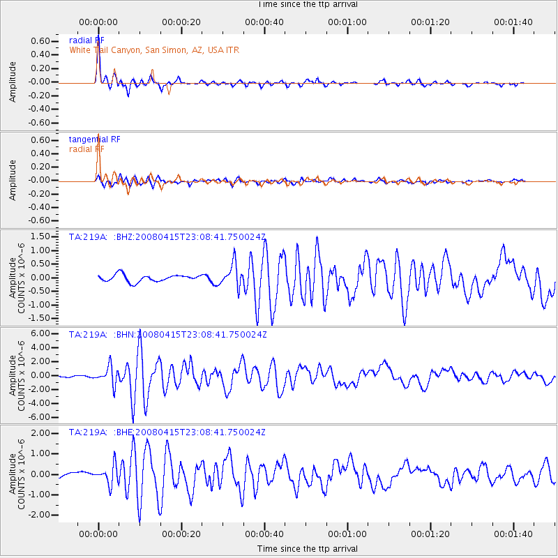
| Earthquake location: |
Andreanof Islands, Aleutian Is. |
| Earthquake latitude/longitude: |
51.9/-179.4 |
| Earthquake time(UTC): |
2008/04/15 (106) 22:59:51 GMT |
| Earthquake Depth: |
10 km |
| Earthquake Magnitude: |
6.1 MB, 6.4 MS, 6.4 MW, 6.4 MW |
| Earthquake Catalog/Contributor: |
WHDF/NEIC |
|
| Network: |
TA USArray Transportable Network (new EarthScope stations) |
| Station: |
219A White Tail Canyon, San Simon, AZ, USA |
| Lat/Lon: |
32.00 N/109.26 W |
| Elevation: |
1581 m |
|
| Distance: |
53.6 deg |
| Az: |
82.851 deg |
| Baz: |
313.589 deg |
| Ray Param: |
0.06597343 |
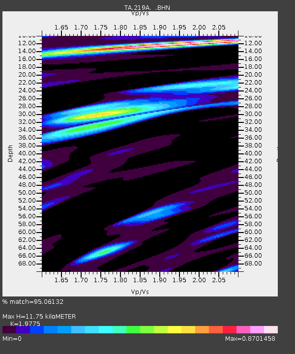
| Estimated Moho Depth: |
11.75 km |
| Estimated Crust Vp/Vs: |
1.98 |
| Assumed Crust Vp: |
6.182 km/s |
| Estimated Crust Vs: |
3.126 km/s |
| Estimated Crust Poisson's Ratio: |
0.33 |
|
| Radial Match: |
95.06132 % |
| Radial Bump: |
400 |
| Transverse Match: |
80.0689 % |
| Transverse Bump: |
400 |
| SOD ConfigId: |
2504 |
| Insert Time: |
2010-03-06 17:54:30.111 +0000 |
| GWidth: |
2.5 |
| Max Bumps: |
400 |
| Tol: |
0.001 |
|
Signal To Noise
| Channel | StoN | STA | LTA |
| TA:219A: :BHN:20080415T23:08:41.750024Z | 13.554732 | 1.2745519E-6 | 9.403003E-8 |
| TA:219A: :BHE:20080415T23:08:41.750024Z | 3.6606565 | 4.7227917E-7 | 1.290149E-7 |
| TA:219A: :BHZ:20080415T23:08:41.750024Z | 3.3119152 | 4.2158558E-7 | 1.272936E-7 |
| Arrivals |
| Ps | 1.9 SECOND |
| PpPs | 5.4 SECOND |
| PsPs/PpSs | 7.4 SECOND |


