You are here: Home > Network List > TA - USArray Transportable Network (new EarthScope stations) Stations List
> Station J20K Nowitna River, AK, USA > Earthquake Result Viewer
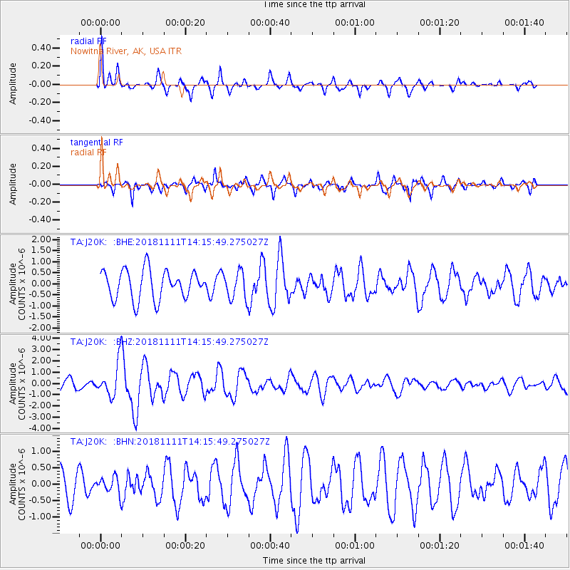
J20K Nowitna River, AK, USA - Earthquake Result Viewer
*The percent match for this event was below the threshold and hence no stack was calculated.
| Earthquake location: |
North Atlantic Ocean |
| Earthquake latitude/longitude: |
15.6/-49.9 |
| Earthquake time(UTC): |
2018/11/11 (315) 14:03:59 GMT |
| Earthquake Depth: |
10 km |
| Earthquake Magnitude: |
6.2 mb |
| Earthquake Catalog/Contributor: |
NEIC PDE/us |
|
| Network: |
TA USArray Transportable Network (new EarthScope stations) |
| Station: |
J20K Nowitna River, AK, USA |
| Lat/Lon: |
64.18 N/154.15 W |
| Elevation: |
314 m |
|
| Distance: |
82.2 deg |
| Az: |
334.635 deg |
| Baz: |
70.512 deg |
| Ray Param: |
$rayparam |
*The percent match for this event was below the threshold and hence was not used in the summary stack. |
|
| Radial Match: |
67.57195 % |
| Radial Bump: |
280 |
| Transverse Match: |
65.52522 % |
| Transverse Bump: |
352 |
| SOD ConfigId: |
13570011 |
| Insert Time: |
2019-05-01 19:26:44.838 +0000 |
| GWidth: |
2.5 |
| Max Bumps: |
400 |
| Tol: |
0.001 |
|
Signal To Noise
| Channel | StoN | STA | LTA |
| TA:J20K: :BHZ:20181111T14:15:49.275027Z | 3.0663733 | 1.5681793E-6 | 5.1141177E-7 |
| TA:J20K: :BHN:20181111T14:15:49.275027Z | 0.5033707 | 2.563846E-7 | 5.0933556E-7 |
| TA:J20K: :BHE:20181111T14:15:49.275027Z | 0.9745714 | 6.420453E-7 | 6.5879755E-7 |
| Arrivals |
| Ps | |
| PpPs | |
| PsPs/PpSs | |


