You are here: Home > Network List > TA - USArray Transportable Network (new EarthScope stations) Stations List
> Station 219A White Tail Canyon, San Simon, AZ, USA > Earthquake Result Viewer
219A White Tail Canyon, San Simon, AZ, USA - Earthquake Result Viewer
| Earthquake location: |
Andreanof Islands, Aleutian Is. |
| Earthquake latitude/longitude: |
51.9/-179.2 |
| Earthquake time(UTC): |
2008/04/16 (107) 05:54:19 GMT |
| Earthquake Depth: |
13 km |
| Earthquake Magnitude: |
6.1 MB, 6.5 MS, 6.6 MW, 6.6 MW |
| Earthquake Catalog/Contributor: |
WHDF/NEIC |
|
| Network: |
TA USArray Transportable Network (new EarthScope stations) |
| Station: |
219A White Tail Canyon, San Simon, AZ, USA |
| Lat/Lon: |
32.00 N/109.26 W |
| Elevation: |
1581 m |
|
| Distance: |
53.5 deg |
| Az: |
83.009 deg |
| Baz: |
313.6 deg |
| Ray Param: |
0.06604752 |
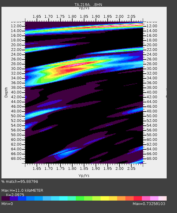
| Estimated Moho Depth: |
11.0 km |
| Estimated Crust Vp/Vs: |
2.10 |
| Assumed Crust Vp: |
6.182 km/s |
| Estimated Crust Vs: |
2.947 km/s |
| Estimated Crust Poisson's Ratio: |
0.35 |
|
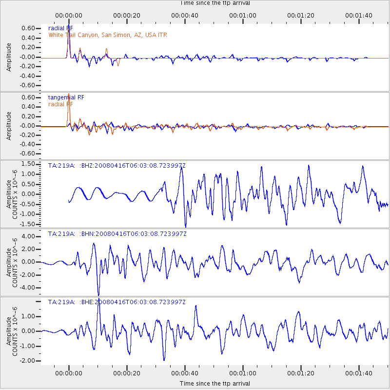
| Radial Match: |
95.88796 % |
| Radial Bump: |
306 |
| Transverse Match: |
70.000496 % |
| Transverse Bump: |
400 |
| SOD ConfigId: |
2504 |
| Insert Time: |
2010-03-06 17:54:32.041 +0000 |
| GWidth: |
2.5 |
| Max Bumps: |
400 |
| Tol: |
0.001 |
|
Signal To Noise
| Channel | StoN | STA | LTA |
| TA:219A: :BHN:20080416T06:03:08.723997Z | 2.5534742 | 5.8001655E-7 | 2.2714799E-7 |
| TA:219A: :BHE:20080416T06:03:08.723997Z | 1.8191947 | 2.2497544E-7 | 1.236676E-7 |
| TA:219A: :BHZ:20080416T06:03:08.723997Z | 1.437827 | 2.9442404E-7 | 2.0477015E-7 |
| Arrivals |
| Ps | 2.0 SECOND |
| PpPs | 5.3 SECOND |
| PsPs/PpSs | 7.3 SECOND |


