You are here: Home > Network List > TA - USArray Transportable Network (new EarthScope stations) Stations List
> Station J26L Joseph Creek, AK, USA > Earthquake Result Viewer
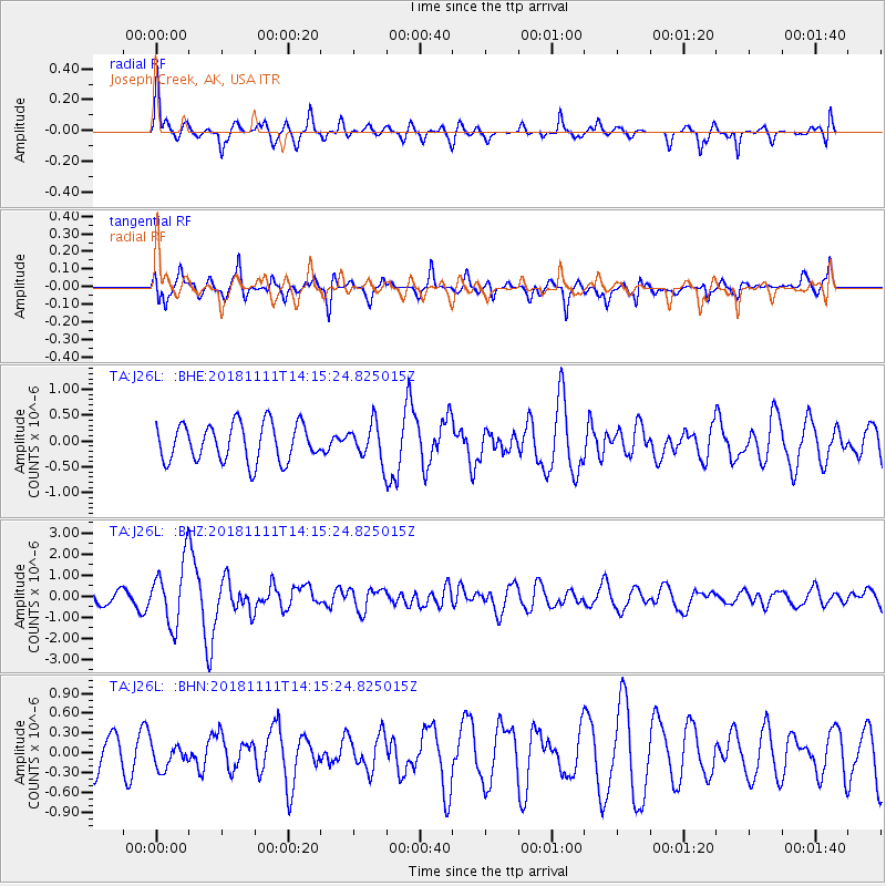
J26L Joseph Creek, AK, USA - Earthquake Result Viewer
*The percent match for this event was below the threshold and hence no stack was calculated.
| Earthquake location: |
North Atlantic Ocean |
| Earthquake latitude/longitude: |
15.6/-49.9 |
| Earthquake time(UTC): |
2018/11/11 (315) 14:03:59 GMT |
| Earthquake Depth: |
10 km |
| Earthquake Magnitude: |
6.2 mb |
| Earthquake Catalog/Contributor: |
NEIC PDE/us |
|
| Network: |
TA USArray Transportable Network (new EarthScope stations) |
| Station: |
J26L Joseph Creek, AK, USA |
| Lat/Lon: |
64.50 N/143.56 W |
| Elevation: |
1144 m |
|
| Distance: |
77.7 deg |
| Az: |
333.76 deg |
| Baz: |
79.892 deg |
| Ray Param: |
$rayparam |
*The percent match for this event was below the threshold and hence was not used in the summary stack. |
|
| Radial Match: |
73.15512 % |
| Radial Bump: |
400 |
| Transverse Match: |
73.606415 % |
| Transverse Bump: |
400 |
| SOD ConfigId: |
13570011 |
| Insert Time: |
2019-05-01 19:26:46.751 +0000 |
| GWidth: |
2.5 |
| Max Bumps: |
400 |
| Tol: |
0.001 |
|
Signal To Noise
| Channel | StoN | STA | LTA |
| TA:J26L: :BHZ:20181111T14:15:24.825015Z | 4.9747057 | 1.4891174E-6 | 2.9933778E-7 |
| TA:J26L: :BHN:20181111T14:15:24.825015Z | 0.8374908 | 1.8764055E-7 | 2.240509E-7 |
| TA:J26L: :BHE:20181111T14:15:24.825015Z | 0.98119503 | 3.5644132E-7 | 3.6327265E-7 |
| Arrivals |
| Ps | |
| PpPs | |
| PsPs/PpSs | |


