You are here: Home > Network List > TA - USArray Transportable Network (new EarthScope stations) Stations List
> Station P33M Teslin, Yukon, CA > Earthquake Result Viewer
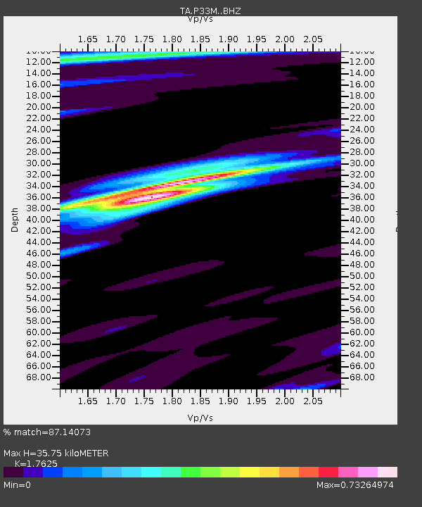
P33M Teslin, Yukon, CA - Earthquake Result Viewer
| Earthquake location: |
North Atlantic Ocean |
| Earthquake latitude/longitude: |
15.6/-49.9 |
| Earthquake time(UTC): |
2018/11/11 (315) 14:03:59 GMT |
| Earthquake Depth: |
10 km |
| Earthquake Magnitude: |
6.2 mb |
| Earthquake Catalog/Contributor: |
NEIC PDE/us |
|
| Network: |
TA USArray Transportable Network (new EarthScope stations) |
| Station: |
P33M Teslin, Yukon, CA |
| Lat/Lon: |
60.21 N/132.82 W |
| Elevation: |
1066 m |
|
| Distance: |
73.1 deg |
| Az: |
328.815 deg |
| Baz: |
88.163 deg |
| Ray Param: |
0.053199485 |
| Estimated Moho Depth: |
35.75 km |
| Estimated Crust Vp/Vs: |
1.76 |
| Assumed Crust Vp: |
6.419 km/s |
| Estimated Crust Vs: |
3.642 km/s |
| Estimated Crust Poisson's Ratio: |
0.26 |
|
| Radial Match: |
87.14073 % |
| Radial Bump: |
336 |
| Transverse Match: |
79.65573 % |
| Transverse Bump: |
400 |
| SOD ConfigId: |
13570011 |
| Insert Time: |
2019-05-01 19:27:21.090 +0000 |
| GWidth: |
2.5 |
| Max Bumps: |
400 |
| Tol: |
0.001 |
|

Signal To Noise
| Channel | StoN | STA | LTA |
| TA:P33M: :BHZ:20181111T14:14:58.825015Z | 6.977952 | 1.3225895E-6 | 1.8953834E-7 |
| TA:P33M: :BHN:20181111T14:14:58.825015Z | 0.8942431 | 1.821401E-7 | 2.0368076E-7 |
| TA:P33M: :BHE:20181111T14:14:58.825015Z | 3.1978648 | 4.9123315E-7 | 1.5361286E-7 |
| Arrivals |
| Ps | 4.4 SECOND |
| PpPs | 15 SECOND |
| PsPs/PpSs | 19 SECOND |


