You are here: Home > Network List > TA - USArray Transportable Network (new EarthScope stations) Stations List
> Station Q32M Nakina River, BC, CAN > Earthquake Result Viewer
Q32M Nakina River, BC, CAN - Earthquake Result Viewer
| Earthquake location: |
North Atlantic Ocean |
| Earthquake latitude/longitude: |
15.6/-49.9 |
| Earthquake time(UTC): |
2018/11/11 (315) 14:03:59 GMT |
| Earthquake Depth: |
10 km |
| Earthquake Magnitude: |
6.2 mb |
| Earthquake Catalog/Contributor: |
NEIC PDE/us |
|
| Network: |
TA USArray Transportable Network (new EarthScope stations) |
| Station: |
Q32M Nakina River, BC, CAN |
| Lat/Lon: |
58.96 N/132.27 W |
| Elevation: |
1951 m |
|
| Distance: |
72.9 deg |
| Az: |
327.494 deg |
| Baz: |
88.249 deg |
| Ray Param: |
0.053356454 |
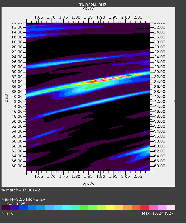
| Estimated Moho Depth: |
32.5 km |
| Estimated Crust Vp/Vs: |
1.93 |
| Assumed Crust Vp: |
6.597 km/s |
| Estimated Crust Vs: |
3.414 km/s |
| Estimated Crust Poisson's Ratio: |
0.32 |
|
| Radial Match: |
87.00142 % |
| Radial Bump: |
400 |
| Transverse Match: |
81.932724 % |
| Transverse Bump: |
400 |
| SOD ConfigId: |
13570011 |
| Insert Time: |
2019-05-01 19:27:24.714 +0000 |
| GWidth: |
2.5 |
| Max Bumps: |
400 |
| Tol: |
0.001 |
|

Signal To Noise
| Channel | StoN | STA | LTA |
| TA:Q32M: :BHZ:20181111T14:14:57.42499Z | 3.7905052 | 8.5091426E-7 | 2.2448572E-7 |
| TA:Q32M: :BHN:20181111T14:14:57.42499Z | 0.80417216 | 2.6862884E-7 | 3.3404393E-7 |
| TA:Q32M: :BHE:20181111T14:14:57.42499Z | 1.7146374 | 4.4522739E-7 | 2.596627E-7 |
| Arrivals |
| Ps | 4.7 SECOND |
| PpPs | 14 SECOND |
| PsPs/PpSs | 19 SECOND |


