You are here: Home > Network List > TA - USArray Transportable Network (new EarthScope stations) Stations List
> Station R11B Troy Canyon, Currant, NV, USA > Earthquake Result Viewer
R11B Troy Canyon, Currant, NV, USA - Earthquake Result Viewer
| Earthquake location: |
North Atlantic Ocean |
| Earthquake latitude/longitude: |
15.6/-49.9 |
| Earthquake time(UTC): |
2018/11/11 (315) 14:03:59 GMT |
| Earthquake Depth: |
10 km |
| Earthquake Magnitude: |
6.2 mb |
| Earthquake Catalog/Contributor: |
NEIC PDE/us |
|
| Network: |
TA USArray Transportable Network (new EarthScope stations) |
| Station: |
R11B Troy Canyon, Currant, NV, USA |
| Lat/Lon: |
38.35 N/115.59 W |
| Elevation: |
1767 m |
|
| Distance: |
61.6 deg |
| Az: |
305.399 deg |
| Baz: |
92.297 deg |
| Ray Param: |
0.06079905 |
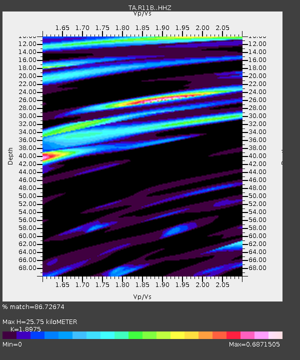
| Estimated Moho Depth: |
25.75 km |
| Estimated Crust Vp/Vs: |
1.90 |
| Assumed Crust Vp: |
6.276 km/s |
| Estimated Crust Vs: |
3.307 km/s |
| Estimated Crust Poisson's Ratio: |
0.31 |
|
| Radial Match: |
86.72674 % |
| Radial Bump: |
400 |
| Transverse Match: |
78.63545 % |
| Transverse Bump: |
400 |
| SOD ConfigId: |
13570011 |
| Insert Time: |
2019-05-01 19:27:25.303 +0000 |
| GWidth: |
2.5 |
| Max Bumps: |
400 |
| Tol: |
0.001 |
|

Signal To Noise
| Channel | StoN | STA | LTA |
| TA:R11B: :HHZ:20181111T14:13:45.609988Z | 11.3171015 | 1.0872644E-6 | 9.607269E-8 |
| TA:R11B: :HHN:20181111T14:13:45.609988Z | 1.2246903 | 1.0850269E-7 | 8.859602E-8 |
| TA:R11B: :HHE:20181111T14:13:45.609988Z | 7.151531 | 4.978204E-7 | 6.961032E-8 |
| Arrivals |
| Ps | 3.8 SECOND |
| PpPs | 11 SECOND |
| PsPs/PpSs | 15 SECOND |


