You are here: Home > Network List > TA - USArray Transportable Network (new EarthScope stations) Stations List
> Station R32K Eaglecrest, AK, USA > Earthquake Result Viewer
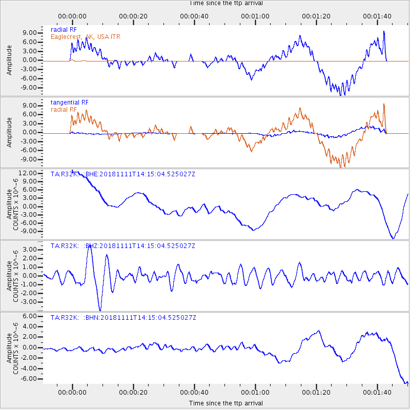
R32K Eaglecrest, AK, USA - Earthquake Result Viewer
*The percent match for this event was below the threshold and hence no stack was calculated.
| Earthquake location: |
North Atlantic Ocean |
| Earthquake latitude/longitude: |
15.6/-49.9 |
| Earthquake time(UTC): |
2018/11/11 (315) 14:03:59 GMT |
| Earthquake Depth: |
10 km |
| Earthquake Magnitude: |
6.2 mb |
| Earthquake Catalog/Contributor: |
NEIC PDE/us |
|
| Network: |
TA USArray Transportable Network (new EarthScope stations) |
| Station: |
R32K Eaglecrest, AK, USA |
| Lat/Lon: |
58.27 N/134.52 W |
| Elevation: |
386 m |
|
| Distance: |
74.1 deg |
| Az: |
326.838 deg |
| Baz: |
86.146 deg |
| Ray Param: |
$rayparam |
*The percent match for this event was below the threshold and hence was not used in the summary stack. |
|
| Radial Match: |
31.32983 % |
| Radial Bump: |
400 |
| Transverse Match: |
71.312935 % |
| Transverse Bump: |
400 |
| SOD ConfigId: |
13570011 |
| Insert Time: |
2019-05-01 19:27:26.905 +0000 |
| GWidth: |
2.5 |
| Max Bumps: |
400 |
| Tol: |
0.001 |
|
Signal To Noise
| Channel | StoN | STA | LTA |
| TA:R32K: :BHZ:20181111T14:15:04.525027Z | 2.9269185 | 7.464153E-7 | 2.5501745E-7 |
| TA:R32K: :BHN:20181111T14:15:04.525027Z | 0.90501875 | 6.682842E-7 | 7.384203E-7 |
| TA:R32K: :BHE:20181111T14:15:04.525027Z | 1.7952882 | 7.2395633E-6 | 4.032536E-6 |
| Arrivals |
| Ps | |
| PpPs | |
| PsPs/PpSs | |


